Villebarou elevation
Villebarou (Centre, Département du Loir-et-Cher), France elevation is 116 meters and Villebarou elevation in feet is 381 ft above sea level [src 1]. Villebarou is a populated place (feature code) with elevation that is 58 meters (190 ft) smaller than average city elevation in France.
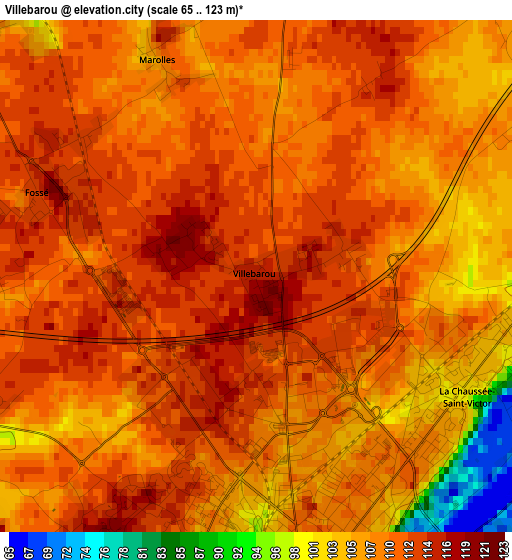
Below is the Elevation map of Villebarou, which displays elevation range with different colors. Scale of the first map is from 65 to 123 m (213 to 404 ft) with average elevation of 108.9 meters (=357 ft) [note 1]
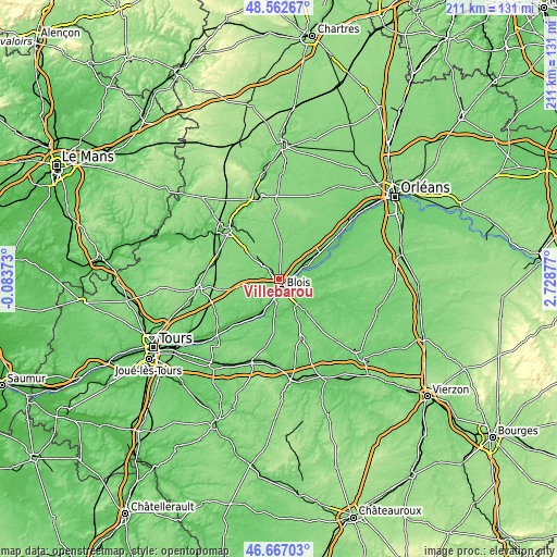
These maps also provides idea of topography and contour of this city, they are displayed at different zoom levels. More info about maps, scale and edge coordinates you can find below images.
| \ | Map #1 | Topo.Map |
| Scale [m] | 65..123 m | × |
| Scale [ft] | 213..404 ft | × |
| Average | 108.9 m = 357 ft | × |
| Width | 6.59 km = 4.1 mi | 210.8 km = 131 mi |
| Height | 6.59 km = 4.1 mi | 210.8 km = 131 mi |
| ↑Max Latitude | 47.653051° | 48.56267° |
| Latitude at center | 47.62344° | 47.62344° |
| ↓Min Latitude | 47.593812° | 46.66703° |
| ← Min Longitude | 1.278575° | -0.08373° |
| Longitude center | 1.32252° | 1.32252° |
| →Max Longitude | 1.366465° | 2.72877° |
Nearby cities:
Cities around Villebarou sort by population:
• Blois elevation 108 m
3.3 km,  171°
171°
• Vineuil 84 m
6 km,  137°
137°
• La Chaussée-Saint-Victor 99 m
3.5 km,  103°
103°
• Saint-Gervais-la-Forêt 98 m
6.7 km,  158°
158°
• Mont-près-Chambord 105 m
12.2 km,  123°
123°
• Cellettes 77 m
11.5 km, 157°
• Chailles 81 m
9.1 km,  184°
184°
• Huisseau-sur-Cosson 78 m
10.4 km,  108°
108°
• Saint-Sulpice-de-Pommeray 109 m
4.9 km,  238°
238°
• Saint-Claude-de-Diray 84 m
7.2 km, 96°
• Suèvres 82 m
11.5 km,  65°
65°
• Montlivault 87 m
9.3 km,  78°
78°
Multilingual:
 En español:
Villebarou elevación 116 m.
 En France:
Villebarou élévation 116 m.
 Auf Deutsch:
Villebarou höhe über dem Meeresspiegel ist 116 m.

Sources and notes:
- [note 1] Map square and city borders are not equal. Map elevation data is calculated only from area inside that square.
- [src 1] Elevation data from geonames database provided with same terms of usage.
- [src 2] The elevation map of Villebarou is generated using elevation data from NASA's 3 arcsec (90m) resolution SRTM data.
- [src 3] Base (background) map © OpenStreetMap contributors tiles are generated by Geofabrik and OpenTopoMap.
Copyright & License:
This Villebarou Elevation Map is licensed under CC BY-SA. You may reuse any part from this page, if you give a proper credit by linking to this URL:
 More info on terms of use page.