Teillé elevation
Teillé (Pays de la Loire, Loire-Atlantique), France elevation is 40 meters and Teillé elevation in feet is 131 ft above sea level [src 1]. Teillé is a populated place (feature code) with elevation that is 134 meters (440 ft) smaller than average city elevation in France.
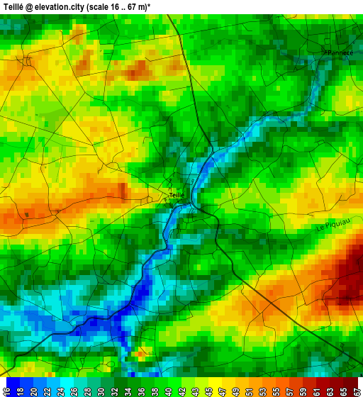
Below is the Elevation map of Teillé, which displays elevation range with different colors. Scale of the first map is from 16 to 67 m (52 to 220 ft) with average elevation of 39.3 meters (=129 ft) [note 1]
These maps also provides idea of topography and contour of this city, they are displayed at different zoom levels. More info about maps, scale and edge coordinates you can find below images.
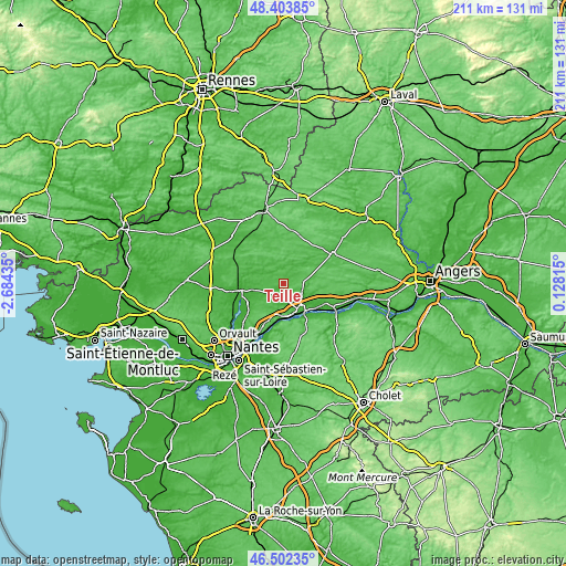
| \ | Map #1 | Topo.Map |
| Scale [m] | 16..67 m | × |
| Scale [ft] | 52..220 ft | × |
| Average | 39.3 m = 129 ft | × |
| Width | 6.61 km = 4.1 mi | 211.4 km = 131.4 mi |
| Height | 6.61 km = 4.1 mi | 211.4 km = 131.4 mi |
| ↑Max Latitude | 47.491402° | 48.40385° |
| Latitude at center | 47.4617° | 47.4617° |
| ↓Min Latitude | 47.431981° | 46.50235° |
| ← Min Longitude | -1.322045° | -2.68435° |
| Longitude center | -1.2781° | -1.2781° |
| →Max Longitude | -1.234155° | 0.12815° |
Nearby cities:
Cities around Teillé sort by population:
• Ancenis elevation 7 m
13.5 km,  141°
141°
• Mésanger 39 m
5.1 km,  131°
131°
• Ligné 36 m
9.4 km,  232°
232°
• Oudon 24 m
12.7 km,  182°
182°
• Saint-Géréon 36 m
11.9 km,  151°
151°
• Saint-Mars-la-Jaille 31 m
10 km,  44°
44°
• Les Touches 27 m
11.7 km,  259°
259°
• Couffé 27 m
7.9 km,  188°
188°
• Riaillé 44 m
6.4 km,  349°
349°
• Bourg de Joué-sur-Erdre 23 m
11.4 km,  289°
289°
• Mouzeil 41 m
5.5 km,  253°
253°
• Pannecé 34 m
4 km,  47°
47°
Multilingual:
 En español:
Teillé elevación 40 m.
 En France:
Teillé élévation 40 m.


Sources and notes:
- [note 1] Map square and city borders are not equal. Map elevation data is calculated only from area inside that square.
- [src 1] Elevation data from geonames database provided with same terms of usage.
- [src 2] The elevation map of Teillé is generated using elevation data from NASA's 3 arcsec (90m) resolution SRTM data.
- [src 3] Base (background) map © OpenStreetMap contributors tiles are generated by Geofabrik and OpenTopoMap.
Copyright & License:
This Teillé Elevation Map is licensed under CC BY-SA. You may reuse any part from this page, if you give a proper credit by linking to this URL:
 More info on terms of use page.