Tende elevation
Tende (Provence-Alpes-Côte d'Azur, Alpes-Maritimes), France elevation is 1061 meters and Tende elevation in feet is 3481 ft above sea level [src 1]. Tende is a populated place (feature code) with elevation that is 887 meters (2910 ft) bigger than average city elevation in France.
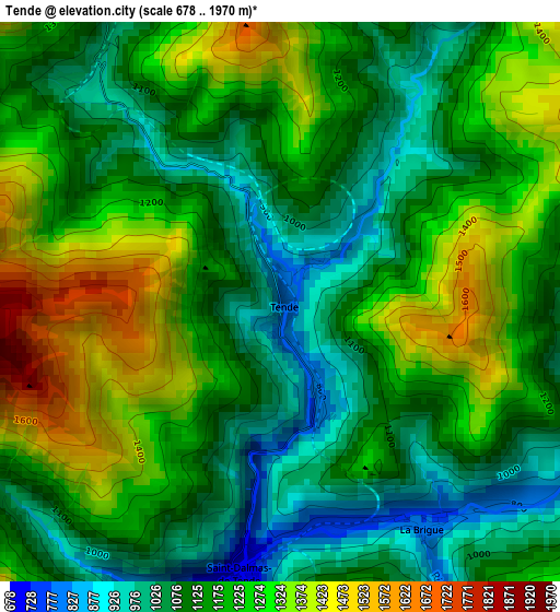
Below is the Elevation map of Tende, which displays elevation range with different colors. Scale of the first map is from 678 to 1970 m (2224 to 6463 ft) with average elevation of 1178.5 meters (=3866 ft) [note 1]
These maps also provides idea of topography and contour of this city, they are displayed at different zoom levels. More info about maps, scale and edge coordinates you can find below images.
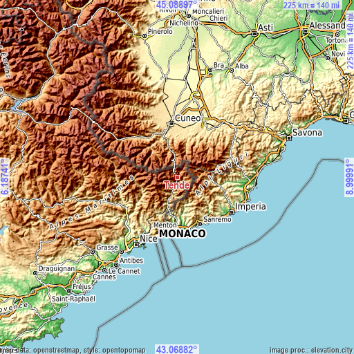
| \ | Map #1 | Topo.Map |
| Scale [m] | 678..1970 m | × |
| Scale [ft] | 2224..6463 ft | × |
| Average | 1178.5 m = 3866 ft | × |
| Width | 7.02 km = 4.4 mi | 224.6 km = 139.6 mi |
| Height | 7.02 km = 4.4 mi | 224.6 km = 139.6 mi |
| ↑Max Latitude | 44.119077° | 45.08897° |
| Latitude at center | 44.08752° | 44.08752° |
| ↓Min Latitude | 44.055947° | 43.06882° |
| ← Min Longitude | 7.549715° | 6.18741° |
| Longitude center | 7.59366° | 7.59366° |
| →Max Longitude | 7.637605° | 8.99991° |
Nearby cities:
Cities around Tende sort by population:
• Menton elevation 17 m
35.3 km,  191°
191°
• Sospel 347 m
26.1 km,  206°
206°
• L’Escarène 474 m
33.9 km, 214°
• Breil-sur-Roya 422 m
17.8 km,  200°
200°
• Peille 818 m
35.2 km, 205°
• Roquebillière 616 m
24.4 km,  249°
249°
• Saint-Martin-Vésubie 1076 m
27.1 km,  265°
265°
• Berre-les-Alpes 542 m
35.6 km,  216°
216°
• Gorbio 369 m
35.5 km, 199°
• Sainte-Agnès 339 m
33.6 km, 198°
• Lucéram 656 m
29.4 km, 219°
• Lantosque 477 m
25.8 km,  240°
240°
Multilingual:
 En español:
Tende elevación 1061 m.
 En France:
Tende élévation 1061 m.


Sources and notes:
- [note 1] Map square and city borders are not equal. Map elevation data is calculated only from area inside that square.
- [src 1] Elevation data from geonames database provided with same terms of usage.
- [src 2] The elevation map of Tende is generated using elevation data from NASA's 3 arcsec (90m) resolution SRTM data.
- [src 3] Base (background) map © OpenStreetMap contributors tiles are generated by Geofabrik and OpenTopoMap.
Copyright & License:
This Tende Elevation Map is licensed under CC BY-SA. You may reuse any part from this page, if you give a proper credit by linking to this URL:
 More info on terms of use page.