Tiffauges elevation
Tiffauges (Pays de la Loire, Département de la Vendée), France elevation is 101 meters and Tiffauges elevation in feet is 331 ft above sea level [src 1]. Tiffauges is a populated place (feature code) with elevation that is 73 meters (240 ft) smaller than average city elevation in France.
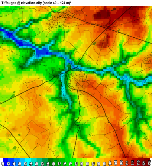
Below is the Elevation map of Tiffauges, which displays elevation range with different colors. Scale of the first map is from 40 to 124 m (131 to 407 ft) with average elevation of 88.8 meters (=291 ft) [note 1]
These maps also provides idea of topography and contour of this city, they are displayed at different zoom levels. More info about maps, scale and edge coordinates you can find below images.
| \ | Map #1 | Topo.Map |
| Scale [m] | 40..124 m | × |
| Scale [ft] | 131..407 ft | × |
| Average | 88.8 m = 291 ft | × |
| Width | 6.66 km = 4.1 mi | 213.2 km = 132.5 mi |
| Height | 6.66 km = 4.1 mi | 213.2 km = 132.5 mi |
| ↑Max Latitude | 47.040756° | 47.96107° |
| Latitude at center | 47.0108° | 47.0108° |
| ↓Min Latitude | 46.980827° | 46.04332° |
| ← Min Longitude | -1.153935° | -2.51624° |
| Longitude center | -1.10999° | -1.10999° |
| →Max Longitude | -1.066045° | 0.29626° |
Nearby cities:
Cities around Tiffauges sort by population:
• La Bruffière elevation 67 m
6.6 km,  273°
273°
• La Gaubretière 156 m
8.5 km,  154°
154°
• Treize-Septiers 66 m
9.5 km,  252°
252°
• Boussay 80 m
6.8 km,  303°
303°
• Les Landes-Genusson 106 m
4.9 km,  185°
185°
• Torfou 102 m
2.9 km,  350°
350°
• Le Longeron 121 m
4.1 km,  77°
77°
• Montfaucon-Montigné 48 m
9.9 km,  357°
357°
• La Boissière-de-Montaigu 80 m
9.1 km,  222°
222°
• La Romagne 97 m
8.8 km,  50°
50°
• Saint-Aubin-des-Ormeaux 133 m
5.5 km,  111°
111°
• Roussay 88 m
9.5 km,  21°
21°
Multilingual:
 En español:
Tiffauges elevación 101 m.
 En France:
Tiffauges élévation 101 m.
 Auf Deutsch:
Tiffauges höhe über dem Meeresspiegel ist 101 m.

Sources and notes:
- [note 1] Map square and city borders are not equal. Map elevation data is calculated only from area inside that square.
- [src 1] Elevation data from geonames database provided with same terms of usage.
- [src 2] The elevation map of Tiffauges is generated using elevation data from NASA's 3 arcsec (90m) resolution SRTM data.
- [src 3] Base (background) map © OpenStreetMap contributors tiles are generated by Geofabrik and OpenTopoMap.
Copyright & License:
This Tiffauges Elevation Map is licensed under CC BY-SA. You may reuse any part from this page, if you give a proper credit by linking to this URL:
 More info on terms of use page.