Tournon-Saint-Martin elevation
Tournon-Saint-Martin (Centre, Département de l'Indre), France elevation is 73 meters and Tournon-Saint-Martin elevation in feet is 240 ft above sea level [src 1]. Tournon-Saint-Martin is a populated place (feature code) with elevation that is 101 meters (331 ft) smaller than average city elevation in France.
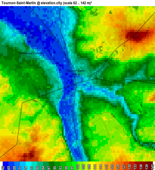
Below is the Elevation map of Tournon-Saint-Martin, which displays elevation range with different colors. Scale of the first map is from 62 to 142 m (203 to 466 ft) with average elevation of 93.9 meters (=308 ft) [note 1]
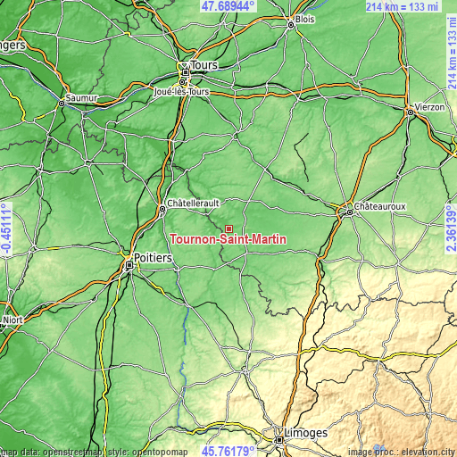
These maps also provides idea of topography and contour of this city, they are displayed at different zoom levels. More info about maps, scale and edge coordinates you can find below images.
| \ | Map #1 | Topo.Map |
| Scale [m] | 62..142 m | × |
| Scale [ft] | 203..466 ft | × |
| Average | 93.9 m = 308 ft | × |
| Width | 6.7 km = 4.2 mi | 214.3 km = 133.2 mi |
| Height | 6.7 km = 4.2 mi | 214.3 km = 133.2 mi |
| ↑Max Latitude | 46.764341° | 47.68944° |
| Latitude at center | 46.73423° | 46.73423° |
| ↓Min Latitude | 46.704102° | 45.76179° |
| ← Min Longitude | 0.911195° | -0.45111° |
| Longitude center | 0.95514° | 0.95514° |
| →Max Longitude | 0.999085° | 2.36139° |
Nearby cities:
Cities around Tournon-Saint-Martin sort by population:
• Le Blanc elevation 115 m
13.9 km,  143°
143°
• La Roche-Posay 59 m
12.3 km,  298°
298°
• Yzeures-sur-Creuse 72 m
8.6 km,  312°
312°
• Pleumartin 137 m
14.4 km,  271°
271°
• Mézières-en-Brenne 90 m
21.7 km,  63°
63°
• Preuilly-sur-Claise 87 m
13.5 km,  351°
351°
• Le Grand-Pressigny 64 m
23.7 km,  330°
330°
• Saint-Savin 80 m
20 km,  200°
200°
• Martizay 82 m
10.6 km,  39°
39°
• Archigny 131 m
24.1 km,  253°
253°
• Pouligny-Saint-Pierre 117 m
8.7 km,  132°
132°
• Azay-le-Ferron 106 m
15.7 km,  34°
34°
Multilingual:
 En español:
Tournon-Saint-Martin elevación 73 m.
 En France:
Tournon-Saint-Martin élévation 73 m.
 Auf Deutsch:
Tournon-Saint-Martin höhe über dem Meeresspiegel ist 73 m.

Sources and notes:
- [note 1] Map square and city borders are not equal. Map elevation data is calculated only from area inside that square.
- [src 1] Elevation data from geonames database provided with same terms of usage.
- [src 2] The elevation map of Tournon-Saint-Martin is generated using elevation data from NASA's 3 arcsec (90m) resolution SRTM data.
- [src 3] Base (background) map © OpenStreetMap contributors tiles are generated by Geofabrik and OpenTopoMap.
Copyright & License:
This Tournon-Saint-Martin Elevation Map is licensed under CC BY-SA. You may reuse any part from this page, if you give a proper credit by linking to this URL:
 More info on terms of use page.