Trégunc elevation
Trégunc (Brittany, Département du Finistère), France elevation is 35 meters and Trégunc elevation in feet is 115 ft above sea level [src 1]. Trégunc is a populated place (feature code) with elevation that is 139 meters (456 ft) smaller than average city elevation in France.
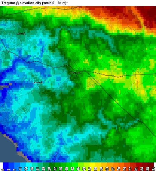
Below is the Elevation map of Trégunc, which displays elevation range with different colors. Scale of the first map is from 0 to 91 m (0 to 299 ft) with average elevation of 31.6 meters (=104 ft) [note 1]
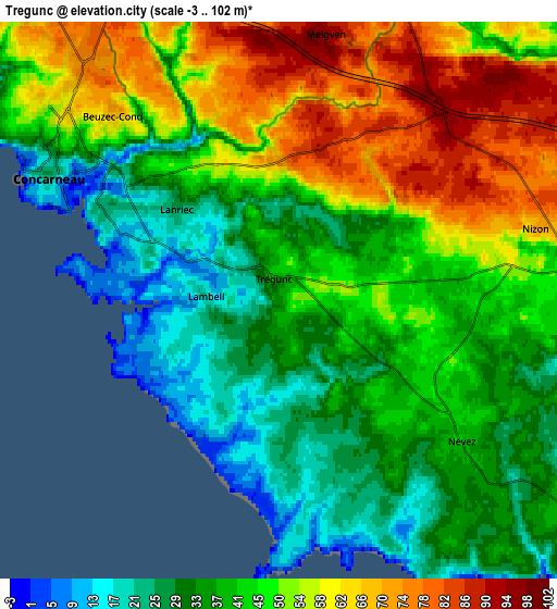
These maps also provides idea of topography and contour of this city, they are displayed at different zoom levels. More info about maps, scale and edge coordinates you can find below images.
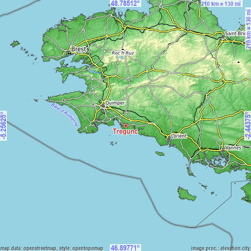
| \ | Map #1 | Map #2 | Topo.Map |
| Scale [m] | 0..91 m | -3..102 m | × |
| Scale [ft] | 0..299 ft | -10..335 ft | × |
| Average | 31.6 m = 104 ft | 45 m = 148 ft | × |
| Width | 6.56 km = 4.1 mi | 13.12 km = 8.2 mi | 209.9 km = 130.4 mi |
| Height | 6.56 km = 4.1 mi | 13.12 km = 8.2 mi | 209.8 km = 130.4 mi |
| ↑Max Latitude | 47.879482° | 47.908948° | 48.78512° |
| Latitude at center | 47.85° | 47.85° | 47.85° |
| ↓Min Latitude | 47.820501° | 47.790985° | 46.89771° |
| ← Min Longitude | -3.893945° | -3.937891° | -5.25625° |
| Longitude center | -3.85° | -3.85° | -3.85° |
| →Max Longitude | -3.806055° | -3.762109° | -2.44375° |
Nearby cities:
Cities around Trégunc sort by population:
• Concarneau elevation 21 m
6.1 km,  297°
297°
• Fouesnant 67 m
13.1 km,  290°
290°
• Rosporden 121 m
13 km,  5°
5°
• Bannalec 94 m
14.6 km,  51°
51°
• Riec-sur-Belon 27 m
11.3 km,  99°
99°
• Pont-Aven 31 m
7.5 km,  90°
90°
• Melgven 96 m
6.4 km, 10°
• La Forêt-Fouesnant 7 m
11.7 km, 304°
• Saint-Yvi 113 m
14.4 km,  334°
334°
• Pleuven 75 m
14.8 km, 292°
• Névez 42 m
5.5 km,  128°
128°
• Lanmeur 55 m
10.1 km, 100°
Multilingual:
 En español:
Trégunc elevación 35 m.
 En France:
Trégunc élévation 35 m.


Sources and notes:
- [note 1] Map square and city borders are not equal. Map elevation data is calculated only from area inside that square.
- [src 1] Elevation data from geonames database provided with same terms of usage.
- [src 2] The elevation map of Trégunc is generated using elevation data from NASA's 3 arcsec (90m) resolution SRTM data.
- [src 3] Base (background) map © OpenStreetMap contributors tiles are generated by Geofabrik and OpenTopoMap.
Copyright & License:
This Trégunc Elevation Map is licensed under CC BY-SA. You may reuse any part from this page, if you give a proper credit by linking to this URL:
 More info on terms of use page.