Trept elevation
Trept (Auvergne-Rhône-Alpes, Département de l'Isère), France elevation is 240 meters and Trept elevation in feet is 787 ft above sea level [src 1]. Trept is a populated place (feature code) with elevation that is 66 meters (217 ft) bigger than average city elevation in France.
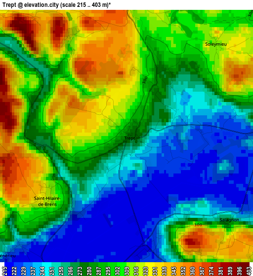
Below is the Elevation map of Trept, which displays elevation range with different colors. Scale of the first map is from 215 to 403 m (705 to 1322 ft) with average elevation of 286.3 meters (=939 ft) [note 1]
These maps also provides idea of topography and contour of this city, they are displayed at different zoom levels. More info about maps, scale and edge coordinates you can find below images.
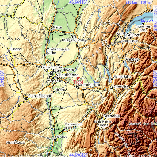
| \ | Map #1 | Topo.Map |
| Scale [m] | 215..403 m | × |
| Scale [ft] | 705..1322 ft | × |
| Average | 286.3 m = 939 ft | × |
| Width | 6.83 km = 4.2 mi | 218.5 km = 135.8 mi |
| Height | 6.83 km = 4.2 mi | 218.4 km = 135.7 mi |
| ↑Max Latitude | 45.718111° | 46.66116° |
| Latitude at center | 45.68742° | 45.68742° |
| ↓Min Latitude | 45.656713° | 44.69642° |
| ← Min Longitude | 5.274485° | 3.91218° |
| Longitude center | 5.31843° | 5.31843° |
| →Max Longitude | 5.362375° | 6.72468° |
Nearby cities:
Cities around Trept sort by population:
• L’Isle-d’Abeau elevation 232 m
10.5 km,  224°
224°
• Ruy 313 m
11.2 km,  178°
178°
• Crémieu 222 m
6.9 km,  308°
308°
• Morestel 227 m
11.4 km,  94°
94°
• Saint-Chef 320 m
6.8 km,  147°
147°
• Saint-Savin 261 m
6.7 km,  186°
186°
• Saint-Romain-de-Jalionas 210 m
11 km, 314°
• Frontonas 309 m
10.6 km,  243°
243°
• Villemoirieu 212 m
8 km,  295°
295°
• Chamagnieu 294 m
11.6 km,  267°
267°
• Sermérieu 329 m
7.5 km,  105°
105°
• Salagnon 230 m
4.1 km,  120°
120°
Multilingual:
 En español:
Trept elevación 240 m.
 En France:
Trept élévation 240 m.


Sources and notes:
- [note 1] Map square and city borders are not equal. Map elevation data is calculated only from area inside that square.
- [src 1] Elevation data from geonames database provided with same terms of usage.
- [src 2] The elevation map of Trept is generated using elevation data from NASA's 3 arcsec (90m) resolution SRTM data.
- [src 3] Base (background) map © OpenStreetMap contributors tiles are generated by Geofabrik and OpenTopoMap.
Copyright & License:
This Trept Elevation Map is licensed under CC BY-SA. You may reuse any part from this page, if you give a proper credit by linking to this URL:
 More info on terms of use page.