Ugine elevation
Ugine (Auvergne-Rhône-Alpes, Savoie), France elevation is 471 meters and Ugine elevation in feet is 1545 ft above sea level [src 1]. Ugine is a populated place (feature code) with elevation that is 297 meters (974 ft) bigger than average city elevation in France.
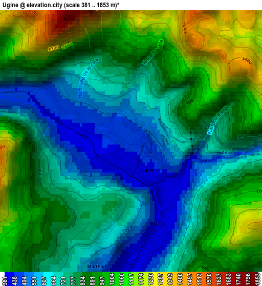
Below is the Elevation map of Ugine, which displays elevation range with different colors. Scale of the first map is from 381 to 1853 m (1250 to 6079 ft) with average elevation of 827.6 meters (=2715 ft) [note 1]
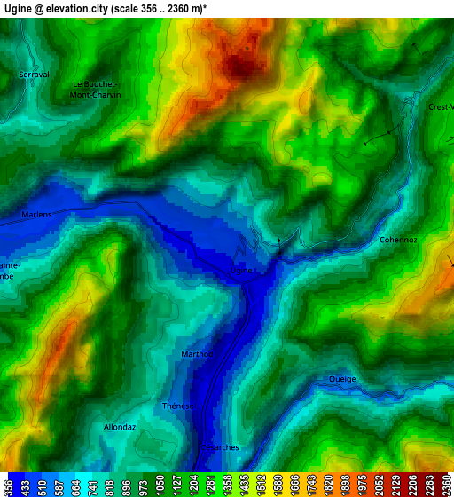
These maps also provides idea of topography and contour of this city, they are displayed at different zoom levels. More info about maps, scale and edge coordinates you can find below images.
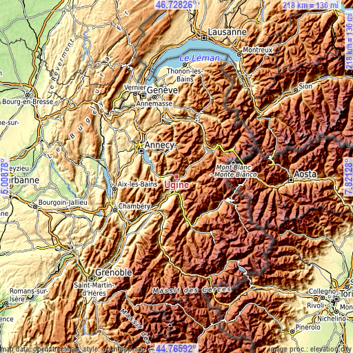
| \ | Map #1 | Map #2 | Topo.Map |
| Scale [m] | 381..1853 m | 356..2360 m | × |
| Scale [ft] | 1250..6079 ft | 1168..7743 ft | × |
| Average | 827.6 m = 2715 ft | 1030.2 m = 3380 ft | × |
| Width | 6.82 km = 4.2 mi | 13.64 km = 8.5 mi | 218.2 km = 135.6 mi |
| Height | 6.82 km = 4.2 mi | 13.64 km = 8.5 mi | 218.2 km = 135.6 mi |
| ↑Max Latitude | 45.786363° | 45.816999° | 46.72826° |
| Latitude at center | 45.75571° | 45.75571° | 45.75571° |
| ↓Min Latitude | 45.72504° | 45.694353° | 44.76592° |
| ← Min Longitude | 6.371085° | 6.327139° | 5.00878° |
| Longitude center | 6.41503° | 6.41503° | 6.41503° |
| →Max Longitude | 6.458975° | 6.502921° | 7.82128° |
Nearby cities:
Cities around Ugine sort by population:
• Albertville elevation 346 m
9.2 km,  191°
191°
• Faverges 508 m
9.6 km,  266°
266°
• Thônes 627 m
15.6 km,  333°
333°
• Doussard 466 m
14.9 km,  278°
278°
• Gilly-sur-Isère 341 m
11.8 km,  204°
204°
• Mercury 552 m
10.9 km,  213°
213°
• La Bâthie 457 m
14.4 km,  169°
169°
• Beaufort 863 m
12.9 km,  108°
108°
• Grignon 331 m
12 km, 193°
• Frontenex 319 m
15.8 km, 210°
• Marthod 417 m
3.3 km, 196°
• Praz-sur-Arly 1012 m
15.2 km,  53°
53°
Multilingual:
 En español:
Ugine elevación 471 m.
 En France:
Ugine élévation 471 m.


Sources and notes:
- [note 1] Map square and city borders are not equal. Map elevation data is calculated only from area inside that square.
- [src 1] Elevation data from geonames database provided with same terms of usage.
- [src 2] The elevation map of Ugine is generated using elevation data from NASA's 3 arcsec (90m) resolution SRTM data.
- [src 3] Base (background) map © OpenStreetMap contributors tiles are generated by Geofabrik and OpenTopoMap.
Copyright & License:
This Ugine Elevation Map is licensed under CC BY-SA. You may reuse any part from this page, if you give a proper credit by linking to this URL:
 More info on terms of use page.