Vaugneray elevation
Vaugneray (Auvergne-Rhône-Alpes, Département du Rhône), France elevation is 415 meters and Vaugneray elevation in feet is 1362 ft above sea level [src 1]. Vaugneray is a populated place (feature code) with elevation that is 241 meters (791 ft) bigger than average city elevation in France.
Below is the Elevation map of Vaugneray, which displays elevation range with different colors. Scale of the first map is from 271 to 819 m (889 to 2687 ft) with average elevation of 451.4 meters (=1481 ft) [note 1]
These maps also provides idea of topography and contour of this city, they are displayed at different zoom levels. More info about maps, scale and edge coordinates you can find below images.
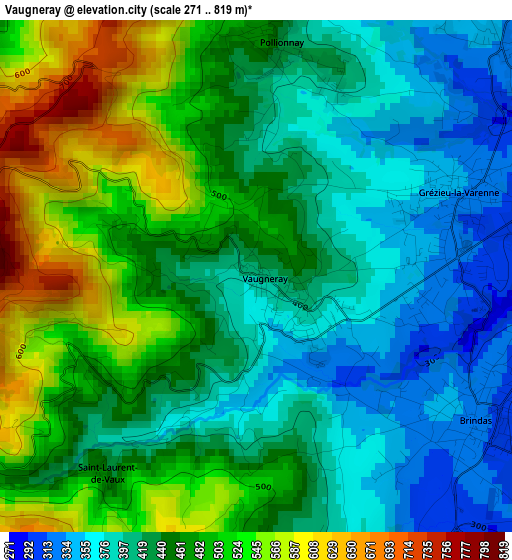
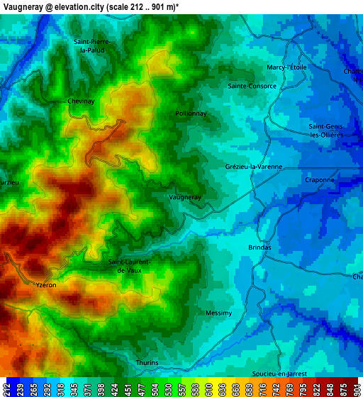

| \ | Map #1 | Map #2 | Topo.Map |
| Scale [m] | 271..819 m | 212..901 m | × |
| Scale [ft] | 889..2687 ft | 696..2956 ft | × |
| Average | 451.4 m = 1481 ft | 436.8 m = 1433 ft | × |
| Width | 6.82 km = 4.2 mi | 13.64 km = 8.5 mi | 218.3 km = 135.6 mi |
| Height | 6.82 km = 4.2 mi | 13.64 km = 8.5 mi | 218.2 km = 135.6 mi |
| ↑Max Latitude | 45.768573° | 45.799219° | 46.71077° |
| Latitude at center | 45.73791° | 45.73791° | 45.73791° |
| ↓Min Latitude | 45.70723° | 45.676534° | 44.7478° |
| ← Min Longitude | 4.612505° | 4.568559° | 3.2502° |
| Longitude center | 4.65645° | 4.65645° | 4.65645° |
| →Max Longitude | 4.700395° | 4.744341° | 6.0627° |
Nearby cities:
Cities around Vaugneray sort by population:
• Craponne elevation 275 m
5.2 km,  81°
81°
• Chaponost 317 m
7.3 km,  114°
114°
• Saint-Genis-les-Ollières 255 m
5.8 km,  68°
68°
• Brindas 289 m
3.4 km,  123°
123°
• Grézieu-la-Varenne 312 m
2.8 km, 68°
• Soucieu-en-Jarrest 320 m
7.6 km,  151°
151°
• Messimy 331 m
4.6 km,  162°
162°
• Thurins 347 m
6.4 km,  191°
191°
• Saint-Pierre-la-Palud 423 m
6.8 km,  329°
329°
• Sainte-Consorce 363 m
5 km,  31°
31°
• Pollionnay 427 m
3 km,  6°
6°
• Courzieu 380 m
6.7 km,  274°
274°
Multilingual:
 En español:
Vaugneray elevación 415 m.
 En France:
Vaugneray élévation 415 m.
 Auf Deutsch:
Vaugneray höhe über dem Meeresspiegel ist 415 m.

Sources and notes:
- [note 1] Map square and city borders are not equal. Map elevation data is calculated only from area inside that square.
- [src 1] Elevation data from geonames database provided with same terms of usage.
- [src 2] The elevation map of Vaugneray is generated using elevation data from NASA's 3 arcsec (90m) resolution SRTM data.
- [src 3] Base (background) map © OpenStreetMap contributors tiles are generated by Geofabrik and OpenTopoMap.
Copyright & License:
This Vaugneray Elevation Map is licensed under CC BY-SA. You may reuse any part from this page, if you give a proper credit by linking to this URL:
 More info on terms of use page.