Vigneulles-lès-Hattonchâtel elevation
Vigneulles-lès-Hattonchâtel (Grand Est, Meuse), France elevation is 259 meters and Vigneulles-lès-Hattonchâtel elevation in feet is 850 ft above sea level [src 1]. Vigneulles-lès-Hattonchâtel is a populated place (feature code) with elevation that is 85 meters (279 ft) bigger than average city elevation in France.
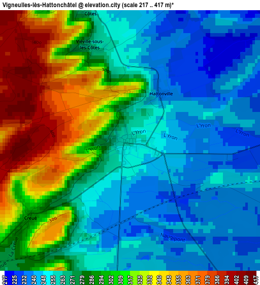
Below is the Elevation map of Vigneulles-lès-Hattonchâtel, which displays elevation range with different colors. Scale of the first map is from 217 to 417 m (712 to 1368 ft) with average elevation of 281 meters (=922 ft) [note 1]
These maps also provides idea of topography and contour of this city, they are displayed at different zoom levels. More info about maps, scale and edge coordinates you can find below images.
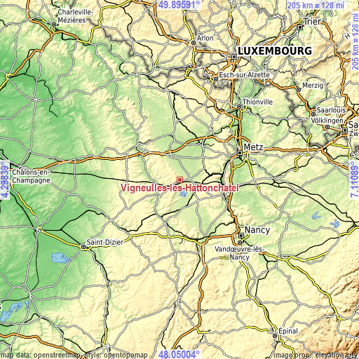
| \ | Map #1 | Topo.Map |
| Scale [m] | 217..417 m | × |
| Scale [ft] | 712..1368 ft | × |
| Average | 281 m = 922 ft | × |
| Width | 6.41 km = 4 mi | 205.2 km = 127.5 mi |
| Height | 6.41 km = 4 mi | 205.2 km = 127.5 mi |
| ↑Max Latitude | 49.010353° | 49.89591° |
| Latitude at center | 48.98152° | 48.98152° |
| ↓Min Latitude | 48.95267° | 48.05004° |
| ← Min Longitude | 5.660695° | 4.29839° |
| Longitude center | 5.70464° | 5.70464° |
| →Max Longitude | 5.748585° | 7.11089° |
Nearby cities:
Cities around Vigneulles-lès-Hattonchâtel sort by population:
• Jarny elevation 198 m
23.3 km,  32°
32°
• Saint-Mihiel 226 m
15.3 km,  227°
227°
• Pagny-sur-Moselle 185 m
23.1 km,  89°
89°
• Conflans-en-Jarnisy 194 m
23.4 km, 27°
• Labry 193 m
24.8 km, 31°
• Dieue-sur-Meuse 205 m
22.9 km,  296°
296°
• Gorze 206 m
23 km,  69°
69°
• Lérouville 228 m
24.2 km,  209°
209°
• Vignot 230 m
24.1 km,  196°
196°
• Doncourt-lès-Conflans 251 m
24.5 km,  42°
42°
• Montauville 228 m
25 km,  110°
110°
• Norroy-lès-Pont-à-Mousson 213 m
24.4 km,  102°
102°
Multilingual:
 En español:
Vigneulles-lès-Hattonchâtel elevación 259 m.
 En France:
Vigneulles-lès-Hattonchâtel élévation 259 m.
 Auf Deutsch:
Vigneulles-lès-Hattonchâtel höhe über dem Meeresspiegel ist 259 m.
 На русском:
Vigneulles-lès-Hattonchâtel высота над уровнем моря 259 м
Sources and notes:
- [note 1] Map square and city borders are not equal. Map elevation data is calculated only from area inside that square.
- [src 1] Elevation data from geonames database provided with same terms of usage.
- [src 2] The elevation map of Vigneulles-lès-Hattonchâtel is generated using elevation data from NASA's 3 arcsec (90m) resolution SRTM data.
- [src 3] Base (background) map © OpenStreetMap contributors tiles are generated by Geofabrik and OpenTopoMap.
Copyright & License:
This Vigneulles-lès-Hattonchâtel Elevation Map is licensed under CC BY-SA. You may reuse any part from this page, if you give a proper credit by linking to this URL:
 More info on terms of use page.