Youx elevation
Youx (Auvergne-Rhône-Alpes, Département du Puy-de-Dôme), France elevation is 622 meters and Youx elevation in feet is 2041 ft above sea level [src 1]. Youx is a populated place (feature code) with elevation that is 448 meters (1470 ft) bigger than average city elevation in France.
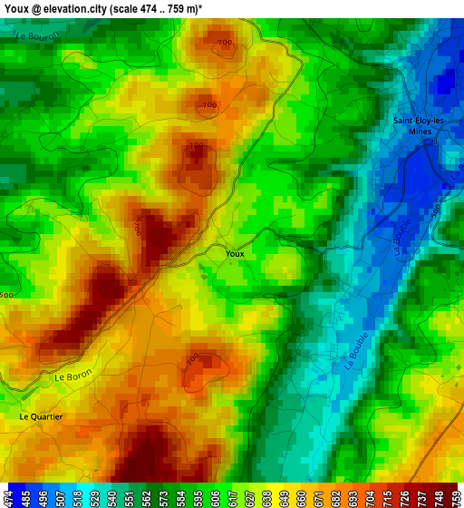
Below is the Elevation map of Youx, which displays elevation range with different colors. Scale of the first map is from 474 to 759 m (1555 to 2490 ft) with average elevation of 613.2 meters (=2012 ft) [note 1]
These maps also provides idea of topography and contour of this city, they are displayed at different zoom levels. More info about maps, scale and edge coordinates you can find below images.
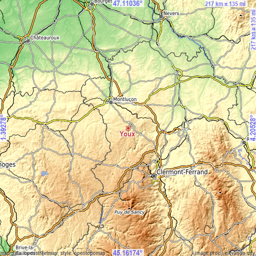
| \ | Map #1 | Topo.Map |
| Scale [m] | 474..759 m | × |
| Scale [ft] | 1555..2490 ft | × |
| Average | 613.2 m = 2012 ft | × |
| Width | 6.77 km = 4.2 mi | 216.7 km = 134.7 mi |
| Height | 6.77 km = 4.2 mi | 216.7 km = 134.7 mi |
| ↑Max Latitude | 46.175109° | 47.11036° |
| Latitude at center | 46.14467° | 46.14467° |
| ↓Min Latitude | 46.114215° | 45.16174° |
| ← Min Longitude | 2.755085° | 1.39278° |
| Longitude center | 2.79903° | 2.79903° |
| →Max Longitude | 2.842975° | 4.20528° |
Nearby cities:
Cities around Youx sort by population:
• Commentry elevation 381 m
16.6 km,  344°
344°
• Saint-Éloy-les-Mines 487 m
3.2 km,  56°
56°
• Néris-les-Bains 359 m
19.1 km,  325°
325°
• Montmarault 477 m
22.6 km,  31°
31°
• Saint-Gervais-d’Auvergne 720 m
12.9 km,  173°
173°
• Ébreuil 310 m
22.4 km,  98°
98°
• Larequille 497 m
14.1 km, 327°
• Doyet 317 m
21.2 km,  359°
359°
• Pionsat 530 m
9 km,  244°
244°
• Montaigut 625 m
3.9 km,  10°
10°
• Villebret 421 m
18.4 km,  317°
317°
• Bellenaves 320 m
22.5 km,  74°
74°
Multilingual:
 En español:
Youx elevación 622 m.
 En France:
Youx élévation 622 m.


Sources and notes:
- [note 1] Map square and city borders are not equal. Map elevation data is calculated only from area inside that square.
- [src 1] Elevation data from geonames database provided with same terms of usage.
- [src 2] The elevation map of Youx is generated using elevation data from NASA's 3 arcsec (90m) resolution SRTM data.
- [src 3] Base (background) map © OpenStreetMap contributors tiles are generated by Geofabrik and OpenTopoMap.
Copyright & License:
This Youx Elevation Map is licensed under CC BY-SA. You may reuse any part from this page, if you give a proper credit by linking to this URL:
 More info on terms of use page.