Alavus elevation
Alavus (Southern Ostrobothnia, Kuusiokunnat), Finland elevation is 107 meters and Alavus elevation in feet is 351 ft above sea level [src 1]. Alavus is a seat of a third-order administrative division (feature code) with elevation that is 30 meters (98 ft) bigger than average city elevation in Finland.
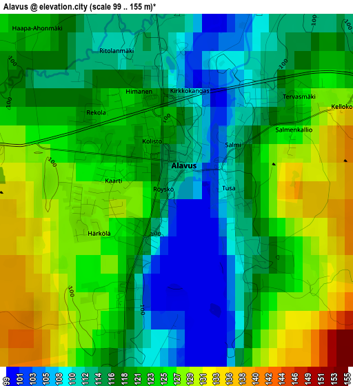
Below is the Elevation map of Alavus, which displays elevation range with different colors. Scale of the first map is from 99 to 155 m (325 to 509 ft) with average elevation of 120.4 meters (=395 ft) [note 1]
These maps also provides idea of topography and contour of this city, they are displayed at different zoom levels. More info about maps, scale and edge coordinates you can find below images.
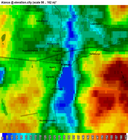
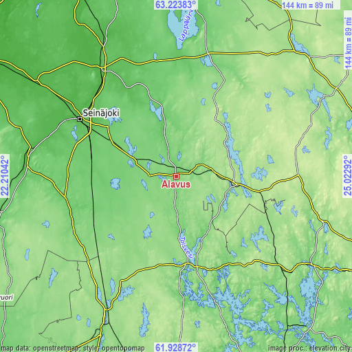
| \ | Map #1 | Map #2 | Topo.Map |
| Scale [m] | 99..155 m | 98..162 m | × |
| Scale [ft] | 325..509 ft | 322..531 ft | × |
| Average | 120.4 m = 395 ft | 127.6 m = 419 ft | × |
| Width | 4.5 km = 2.8 mi | 9 km = 5.6 mi | 144 km = 89.5 mi |
| Height | 4.5 km = 2.8 mi | 9 km = 5.6 mi | 144 km = 89.5 mi |
| ↑Max Latitude | 62.603558° | 62.623772° | 63.22383° |
| Latitude at center | 62.58333° | 62.58333° | 62.58333° |
| ↓Min Latitude | 62.563088° | 62.542832° | 61.92872° |
| ← Min Longitude | 23.572725° | 23.528779° | 22.21042° |
| Longitude center | 23.61667° | 23.61667° | 23.61667° |
| →Max Longitude | 23.660615° | 23.704561° | 25.02292° |
Nearby cities:
Cities around Alavus sort by population:
• Seinäjoki elevation 50 m
46.6 km,  300°
300°
• Nurmo 47 m
45.2 km,  307°
307°
• Älajärvi 107 m
47.5 km,  12°
12°
• Alajärvi 113 m
47.4 km, 12°
• Jalasjärvi 94 m
45.4 km,  258°
258°
• Virrat 127 m
38.3 km,  167°
167°
• Ähtäri 175 m
23 km,  98°
98°
• Kuortane 89 m
24.8 km,  346°
346°
• Töysä 140 m
11.4 km,  64°
64°
• Soini 195 m
43.9 km,  44°
44°
• Kihniö 145 m
48.1 km,  207°
207°
• Lehtimäki 206 m
27 km,  34°
34°
Multilingual:
 En español:
Alavus elevación 107 m.
 En France:
Alavus élévation 107 m.


Sources and notes:
- [note 1] Map square and city borders are not equal. Map elevation data is calculated only from area inside that square.
- [src 1] Elevation data from geonames database provided with same terms of usage.
- [src 2] The elevation map of Alavus is generated using GMTED2010 database with 7.5 arcsec (225m) resolution.
- [src 3] Base (background) map © OpenStreetMap contributors tiles are generated by Geofabrik and OpenTopoMap.
Copyright & License:
This Alavus Elevation Map is licensed under CC BY-SA. You may reuse any part from this page, if you give a proper credit by linking to this URL:
 More info on terms of use page.