Älajärvi elevation
Älajärvi (Southern Ostrobothnia, Järviseutu), Finland elevation is 107 meters and Älajärvi elevation in feet is 351 ft above sea level [src 1]. Älajärvi is a populated locality (feature code) with elevation that is 30 meters (98 ft) bigger than average city elevation in Finland.
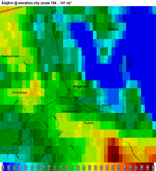
Below is the Elevation map of Älajärvi, which displays elevation range with different colors. Scale of the first map is from 104 to 141 m (341 to 463 ft) with average elevation of 115.8 meters (=380 ft) [note 1]
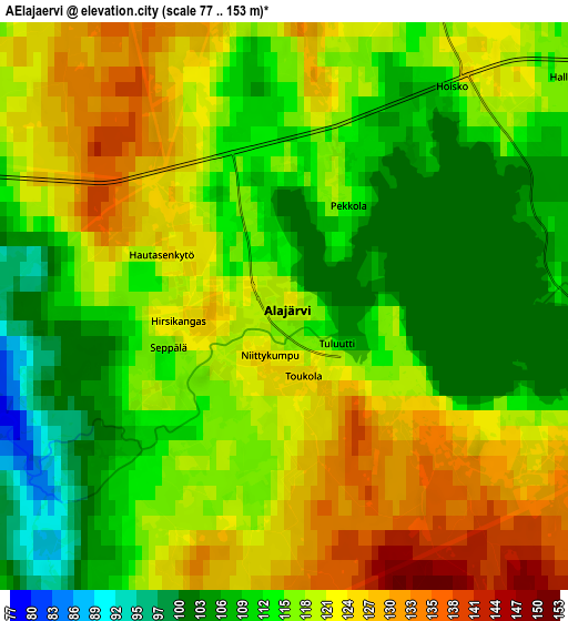
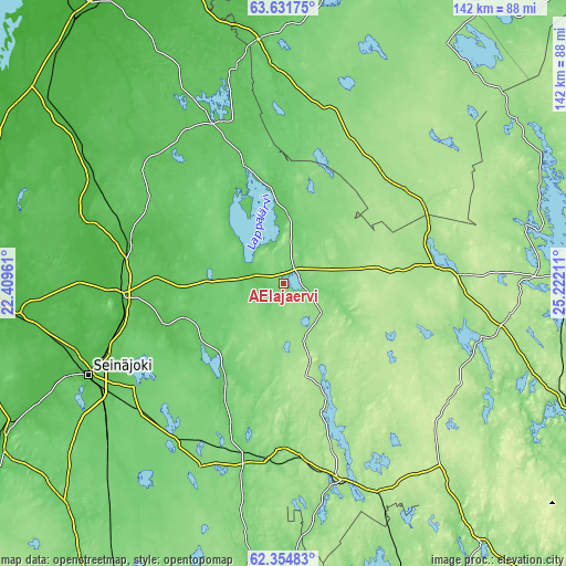
These maps also provides idea of topography and contour of this city, they are displayed at different zoom levels. More info about maps, scale and edge coordinates you can find below images.
| \ | Map #1 | Map #2 | Topo.Map |
| Scale [m] | 104..141 m | 77..153 m | × |
| Scale [ft] | 341..463 ft | 253..502 ft | × |
| Average | 115.8 m = 380 ft | 117.1 m = 384 ft | × |
| Width | 4.44 km = 2.8 mi | 8.87 km = 5.5 mi | 142 km = 88.2 mi |
| Height | 4.44 km = 2.8 mi | 8.87 km = 5.5 mi | 142 km = 88.2 mi |
| ↑Max Latitude | 63.020214° | 63.040144° | 63.63175° |
| Latitude at center | 63.00027° | 63.00027° | 63.00027° |
| ↓Min Latitude | 62.980313° | 62.960342° | 62.35483° |
| ← Min Longitude | 23.771915° | 23.727969° | 22.40961° |
| Longitude center | 23.81586° | 23.81586° | 23.81586° |
| →Max Longitude | 23.859805° | 23.903751° | 25.22211° |
Nearby cities:
Cities around Älajärvi sort by population:
• Lapua elevation 39 m
40.9 km,  265°
265°
• Alajärvi 113 m
0.1 km,  126°
126°
• Kauhava 41 m
39.2 km,  286°
286°
• Kuortane 89 m
27.4 km,  215°
215°
• Lappajärvi 74 m
24 km,  337°
337°
• Vimpeli 72 m
18 km,  0°
0°
• Töysä 140 m
41.4 km,  179°
179°
• Perho 174 m
38.6 km,  51°
51°
• Evijärvi 67 m
44 km, 337°
• Soini 195 m
25.1 km, 126°
• Lehtimäki 206 m
24.7 km,  168°
168°
• Kyyjärvi 186 m
38.1 km,  84°
84°
Multilingual:
 En español:
Älajärvi elevación 107 m.
 En France:
Älajärvi élévation 107 m.
 Auf Deutsch:
Älajärvi höhe über dem Meeresspiegel ist 107 m.

Sources and notes:
- [note 1] Map square and city borders are not equal. Map elevation data is calculated only from area inside that square.
- [src 1] Elevation data from geonames database provided with same terms of usage.
- [src 2] The elevation map of Älajärvi is generated using GMTED2010 database with 7.5 arcsec (225m) resolution.
- [src 3] Base (background) map © OpenStreetMap contributors tiles are generated by Geofabrik and OpenTopoMap.
Copyright & License:
This Älajärvi Elevation Map is licensed under CC BY-SA. You may reuse any part from this page, if you give a proper credit by linking to this URL:
 More info on terms of use page.