Auttoinen elevation
Auttoinen (Päijänne Tavastia, Lahti), Finland elevation is 135 meters and Auttoinen elevation in feet is 443 ft above sea level [src 1]. Auttoinen is a populated place (feature code) with elevation that is 58 meters (190 ft) bigger than average city elevation in Finland.
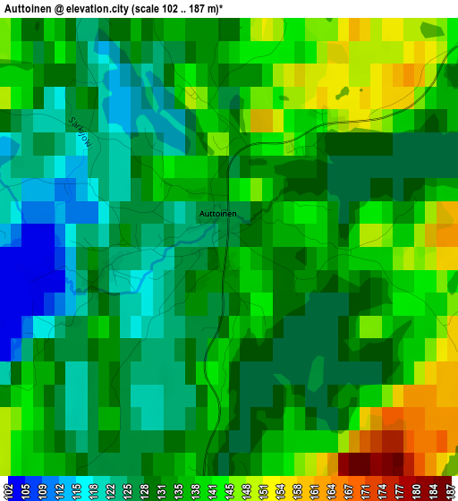
Below is the Elevation map of Auttoinen, which displays elevation range with different colors. Scale of the first map is from 102 to 187 m (335 to 614 ft) with average elevation of 133.6 meters (=438 ft) [note 1]
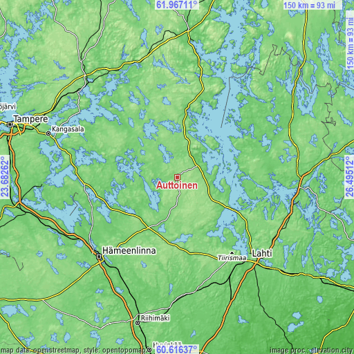
These maps also provides idea of topography and contour of this city, they are displayed at different zoom levels. More info about maps, scale and edge coordinates you can find below images.
| \ | Map #1 | Topo.Map |
| Scale [m] | 102..187 m | × |
| Scale [ft] | 335..614 ft | × |
| Average | 133.6 m = 438 ft | × |
| Width | 4.69 km = 2.9 mi | 150.2 km = 93.3 mi |
| Height | 4.69 km = 2.9 mi | 150.2 km = 93.3 mi |
| ↑Max Latitude | 61.320107° | 61.96711° |
| Latitude at center | 61.29901° | 61.29901° |
| ↓Min Latitude | 61.277899° | 60.61637° |
| ← Min Longitude | 25.044925° | 23.68262° |
| Longitude center | 25.08887° | 25.08887° |
| →Max Longitude | 25.132815° | 26.49512° |
Nearby cities:
Cities around Auttoinen sort by population:
• Hollola elevation 104 m
33.3 km,  146°
146°
• Asikkala 74 m
23.8 km,  112°
112°
• Lammi 129 m
24.3 km,  189°
189°
• Sysmä 74 m
38.7 km,  54°
54°
• Hauho 101 m
31.5 km,  243°
243°
• Padasjoki 113 m
11.8 km,  61°
61°
• Kuhmoinen 108 m
30.2 km,  9°
9°
• Luopioinen 83 m
23.6 km,  287°
287°
• Hämeenkoski 124 m
31 km,  173°
173°
• Tuulos 98 m
22.7 km,  223°
223°
• Kuhmalahti 120 m
35.7 km,  308°
308°
• Hollola 140 m
39.9 km, 146°
Multilingual:
 En español:
Auttoinen elevación 135 m.
 En France:
Auttoinen élévation 135 m.
 Auf Deutsch:
Auttoinen höhe über dem Meeresspiegel ist 135 m.

Sources and notes:
- [note 1] Map square and city borders are not equal. Map elevation data is calculated only from area inside that square.
- [src 1] Elevation data from geonames database provided with same terms of usage.
- [src 2] The elevation map of Auttoinen is generated using GMTED2010 database with 7.5 arcsec (225m) resolution.
- [src 3] Base (background) map © OpenStreetMap contributors tiles are generated by Geofabrik and OpenTopoMap.
Copyright & License:
This Auttoinen Elevation Map is licensed under CC BY-SA. You may reuse any part from this page, if you give a proper credit by linking to this URL:
 More info on terms of use page.