Sysmä elevation
Sysmä (Päijänne Tavastia, Lahti), Finland elevation is 74 meters and Sysmä elevation in feet is 243 ft above sea level [src 1]. Sysmä is a seat of a third-order administrative division (feature code) with elevation that is 3 meters (10 ft) smaller than average city elevation in Finland.
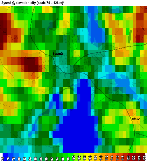
Below is the Elevation map of Sysmä, which displays elevation range with different colors. Scale of the first map is from 74 to 126 m (243 to 413 ft) with average elevation of 93.9 meters (=308 ft) [note 1]
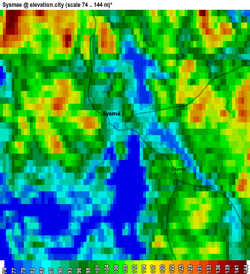
These maps also provides idea of topography and contour of this city, they are displayed at different zoom levels. More info about maps, scale and edge coordinates you can find below images.
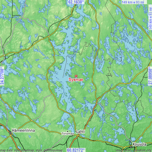
| \ | Map #1 | Map #2 | Topo.Map |
| Scale [m] | 74..126 m | 74..144 m | × |
| Scale [ft] | 243..413 ft | 243..472 ft | × |
| Average | 93.9 m = 308 ft | 98.4 m = 323 ft | × |
| Width | 4.66 km = 2.9 mi | 9.33 km = 5.8 mi | 149.2 km = 92.7 mi |
| Height | 4.66 km = 2.9 mi | 9.33 km = 5.8 mi | 149.2 km = 92.7 mi |
| ↑Max Latitude | 61.520962° | 61.54191° | 62.1638° |
| Latitude at center | 61.5° | 61.5° | 61.5° |
| ↓Min Latitude | 61.479024° | 61.458034° | 60.82172° |
| ← Min Longitude | 25.639385° | 25.595439° | 24.27708° |
| Longitude center | 25.68333° | 25.68333° | 25.68333° |
| →Max Longitude | 25.727275° | 25.771221° | 27.08958° |
Nearby cities:
Cities around Sysmä sort by population:
• Heinola elevation 104 m
37.8 km,  149°
149°
• Hollola 104 m
51.8 km,  194°
194°
• Jämsä 83 m
48.1 km,  327°
327°
• Asikkala 74 m
33 km,  197°
197°
• Joutsa 132 m
34.6 km,  41°
41°
• Hartola 118 m
19.9 km,  62°
62°
• Padasjoki 113 m
27 km,  231°
231°
• Kuhmoinen 108 m
27.5 km,  285°
285°
• Pertunmaa 118 m
42.4 km,  90°
90°
• Auttoinen 135 m
38.7 km, 234°
• Leivonmäki 146 m
51.5 km,  27°
27°
• Luhanka 74 m
33 km,  1°
1°
Multilingual:
 En español:
Sysmä elevación 74 m.
 En France:
Sysmä élévation 74 m.


Sources and notes:
- [note 1] Map square and city borders are not equal. Map elevation data is calculated only from area inside that square.
- [src 1] Elevation data from geonames database provided with same terms of usage.
- [src 2] The elevation map of Sysmä is generated using GMTED2010 database with 7.5 arcsec (225m) resolution.
- [src 3] Base (background) map © OpenStreetMap contributors tiles are generated by Geofabrik and OpenTopoMap.
Copyright & License:
This Sysmä Elevation Map is licensed under CC BY-SA. You may reuse any part from this page, if you give a proper credit by linking to this URL:
 More info on terms of use page.