Hauho elevation
Hauho (Kanta-Hame, Hämeenlinna), Finland elevation is 101 meters and Hauho elevation in feet is 331 ft above sea level [src 1]. Hauho is a seat of a third-order administrative division (feature code) with elevation that is 24 meters (79 ft) bigger than average city elevation in Finland.
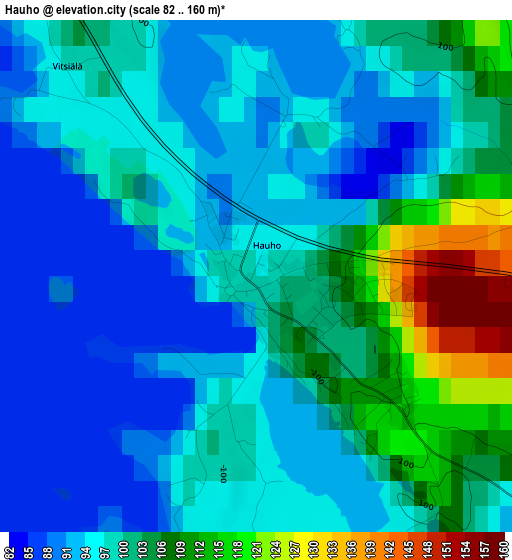
Below is the Elevation map of Hauho, which displays elevation range with different colors. Scale of the first map is from 82 to 160 m (269 to 525 ft) with average elevation of 99 meters (=325 ft) [note 1]
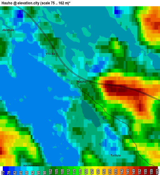
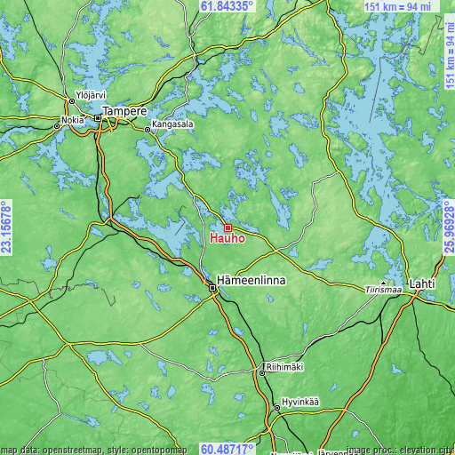
These maps also provides idea of topography and contour of this city, they are displayed at different zoom levels. More info about maps, scale and edge coordinates you can find below images.
| \ | Map #1 | Map #2 | Topo.Map |
| Scale [m] | 82..160 m | 75..162 m | × |
| Scale [ft] | 269..525 ft | 246..531 ft | × |
| Average | 99 m = 325 ft | 101.2 m = 332 ft | × |
| Width | 4.71 km = 2.9 mi | 9.42 km = 5.9 mi | 150.8 km = 93.7 mi |
| Height | 4.71 km = 2.9 mi | 9.42 km = 5.9 mi | 150.8 km = 93.7 mi |
| ↑Max Latitude | 61.193732° | 61.2149° | 61.84335° |
| Latitude at center | 61.17255° | 61.17255° | 61.17255° |
| ↓Min Latitude | 61.151354° | 61.130143° | 60.48717° |
| ← Min Longitude | 24.519085° | 24.475139° | 23.15678° |
| Longitude center | 24.56303° | 24.56303° | 24.56303° |
| →Max Longitude | 24.606975° | 24.650921° | 25.96928° |
Nearby cities:
Cities around Hauho sort by population:
• Hämeenlinna elevation 83 m
20.3 km,  195°
195°
• Valkeakoski 98 m
30.2 km,  289°
289°
• Janakkala 118 m
30.4 km,  176°
176°
• Lammi 129 m
26.3 km,  112°
112°
• Pälkäne 93 m
23.8 km,  319°
319°
• Kalvola 137 m
25 km,  251°
251°
• Luopioinen 83 m
21.9 km,  14°
14°
• Renko 111 m
34.2 km,  205°
205°
• Tuulos 98 m
13 km,  101°
101°
• Auttoinen 135 m
31.5 km,  63°
63°
• Turenki 85 m
28.7 km,  172°
172°
• Parola 119 m
18 km,  218°
218°
Multilingual:
 En español:
Hauho elevación 101 m.
 En France:
Hauho élévation 101 m.


Sources and notes:
- [note 1] Map square and city borders are not equal. Map elevation data is calculated only from area inside that square.
- [src 1] Elevation data from geonames database provided with same terms of usage.
- [src 2] The elevation map of Hauho is generated using GMTED2010 database with 7.5 arcsec (225m) resolution.
- [src 3] Base (background) map © OpenStreetMap contributors tiles are generated by Geofabrik and OpenTopoMap.
Copyright & License:
This Hauho Elevation Map is licensed under CC BY-SA. You may reuse any part from this page, if you give a proper credit by linking to this URL:
 More info on terms of use page.