Mäntyharju elevation
Mäntyharju (South Savo, Mikkeli), Finland elevation is 86 meters and Mäntyharju elevation in feet is 282 ft above sea level [src 1]. Mäntyharju is a seat of a third-order administrative division (feature code) with elevation that is 9 meters (30 ft) bigger than average city elevation in Finland.
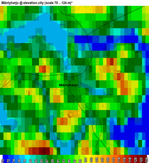
Below is the Elevation map of Mäntyharju, which displays elevation range with different colors. Scale of the first map is from 70 to 124 m (230 to 407 ft) with average elevation of 89.4 meters (=293 ft) [note 1]
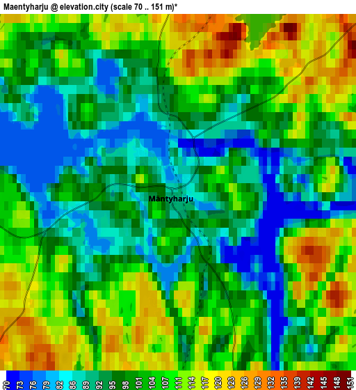
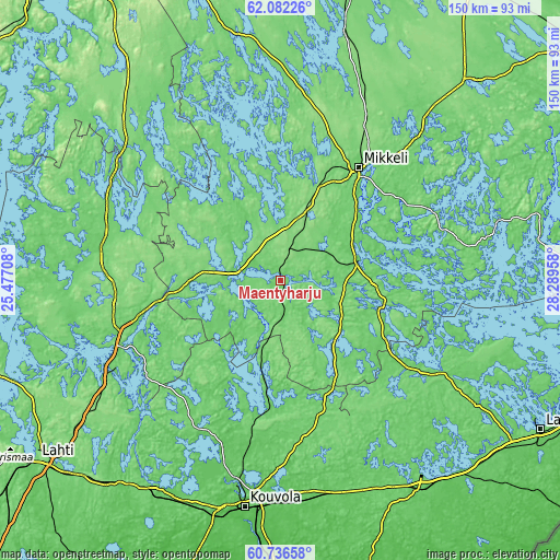
These maps also provides idea of topography and contour of this city, they are displayed at different zoom levels. More info about maps, scale and edge coordinates you can find below images.
| \ | Map #1 | Map #2 | Topo.Map |
| Scale [m] | 70..124 m | 70..151 m | × |
| Scale [ft] | 230..407 ft | 230..495 ft | × |
| Average | 89.4 m = 293 ft | 101.6 m = 333 ft | × |
| Width | 4.68 km = 2.9 mi | 9.35 km = 5.8 mi | 149.6 km = 93 mi |
| Height | 4.68 km = 2.9 mi | 9.35 km = 5.8 mi | 149.6 km = 93 mi |
| ↑Max Latitude | 61.437688° | 61.458692° | 62.08226° |
| Latitude at center | 61.41667° | 61.41667° | 61.41667° |
| ↓Min Latitude | 61.395638° | 61.374592° | 60.73658° |
| ← Min Longitude | 26.839385° | 26.795439° | 25.47708° |
| Longitude center | 26.88333° | 26.88333° | 26.88333° |
| →Max Longitude | 26.927275° | 26.971221° | 28.28958° |
Nearby cities:
Cities around Mäntyharju sort by population:
• Mikkeli elevation 85 m
36.6 km,  34°
34°
• Kouvola 81 m
61.9 km,  189°
189°
• Heinola 104 m
50.9 km,  242°
242°
• Ristiina 68 m
21.7 km,  62°
62°
• Sysmä 74 m
64.4 km,  278°
278°
• Savitaipale 96 m
49.8 km,  118°
118°
• Joutsa 132 m
53.7 km,  310°
310°
• Hartola 118 m
49.6 km,  291°
291°
• Lemi 101 m
63.1 km,  128°
128°
• Hirvensalmi 94 m
24.5 km,  349°
349°
• Pertunmaa 118 m
23.2 km, 293°
• Jaala 108 m
45.9 km,  207°
207°
Multilingual:
 En español:
Mäntyharju elevación 86 m.
 En France:
Mäntyharju élévation 86 m.
 Auf Deutsch:
Mäntyharju höhe über dem Meeresspiegel ist 86 m.

Sources and notes:
- [note 1] Map square and city borders are not equal. Map elevation data is calculated only from area inside that square.
- [src 1] Elevation data from geonames database provided with same terms of usage.
- [src 2] The elevation map of Mäntyharju is generated using GMTED2010 database with 7.5 arcsec (225m) resolution.
- [src 3] Base (background) map © OpenStreetMap contributors tiles are generated by Geofabrik and OpenTopoMap.
Copyright & License:
This Mäntyharju Elevation Map is licensed under CC BY-SA. You may reuse any part from this page, if you give a proper credit by linking to this URL:
 More info on terms of use page.