Savitaipale elevation
Savitaipale (South Karelia, Lappeenranta), Finland elevation is 96 meters and Savitaipale elevation in feet is 315 ft above sea level [src 1]. Savitaipale is a seat of a third-order administrative division (feature code) with elevation that is 19 meters (62 ft) bigger than average city elevation in Finland.
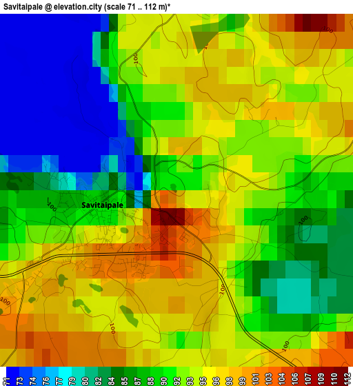
Below is the Elevation map of Savitaipale, which displays elevation range with different colors. Scale of the first map is from 71 to 112 m (233 to 367 ft) with average elevation of 90.9 meters (=298 ft) [note 1]
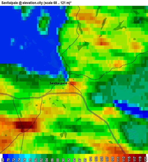
These maps also provides idea of topography and contour of this city, they are displayed at different zoom levels. More info about maps, scale and edge coordinates you can find below images.
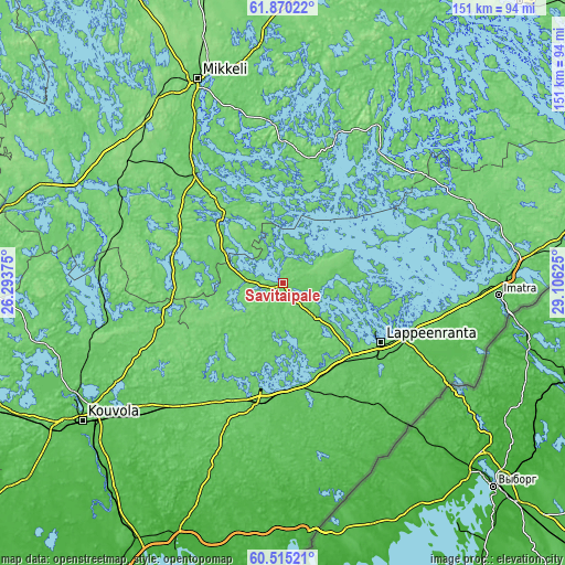
| \ | Map #1 | Map #2 | Topo.Map |
| Scale [m] | 71..112 m | 68..121 m | × |
| Scale [ft] | 233..367 ft | 223..397 ft | × |
| Average | 90.9 m = 298 ft | 89.9 m = 295 ft | × |
| Width | 4.71 km = 2.9 mi | 9.42 km = 5.9 mi | 150.7 km = 93.6 mi |
| Height | 4.71 km = 2.9 mi | 9.42 km = 5.9 mi | 150.6 km = 93.6 mi |
| ↑Max Latitude | 61.221164° | 61.242313° | 61.87022° |
| Latitude at center | 61.2° | 61.2° | 61.2° |
| ↓Min Latitude | 61.178822° | 61.15763° | 60.51521° |
| ← Min Longitude | 27.656055° | 27.612109° | 26.29375° |
| Longitude center | 27.7° | 27.7° | 27.7° |
| →Max Longitude | 27.743945° | 27.787891° | 29.10625° |
Nearby cities:
Cities around Savitaipale sort by population:
• Lappeenranta elevation 104 m
30.6 km,  120°
120°
• Imatra 68 m
56.5 km,  93°
93°
• Joutseno 80 m
44.3 km,  101°
101°
• Mäntyharju 86 m
49.8 km,  298°
298°
• Luumäki 105 m
31.1 km,  191°
191°
• Ristiina 68 m
41.7 km,  324°
324°
• Taipalsaari 68 m
19.6 km,  106°
106°
• Lemi 101 m
16.3 km,  159°
159°
• Puumala 109 m
44.3 km,  34°
34°
• Ylämaa 38 m
47.3 km, 160°
• Nuijamaa 40 m
53 km, 120°
• Taavetti 89 m
32.3 km, 192°
Multilingual:
 En español:
Savitaipale elevación 96 m.
 En France:
Savitaipale élévation 96 m.
 Auf Deutsch:
Savitaipale höhe über dem Meeresspiegel ist 96 m.

Sources and notes:
- [note 1] Map square and city borders are not equal. Map elevation data is calculated only from area inside that square.
- [src 1] Elevation data from geonames database provided with same terms of usage.
- [src 2] The elevation map of Savitaipale is generated using GMTED2010 database with 7.5 arcsec (225m) resolution.
- [src 3] Base (background) map © OpenStreetMap contributors tiles are generated by Geofabrik and OpenTopoMap.
Copyright & License:
This Savitaipale Elevation Map is licensed under CC BY-SA. You may reuse any part from this page, if you give a proper credit by linking to this URL:
 More info on terms of use page.