Tervo elevation
Tervo (Northern Savonia, Sisä-Savo), Finland elevation is 110 meters and Tervo elevation in feet is 361 ft above sea level [src 1]. Tervo is a seat of a third-order administrative division (feature code) with elevation that is 33 meters (108 ft) bigger than average city elevation in Finland.
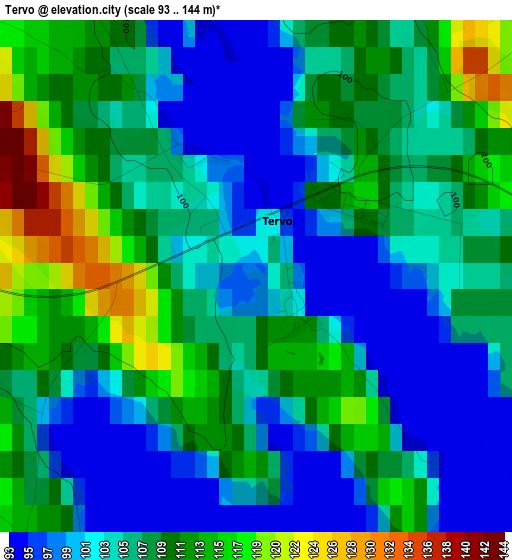
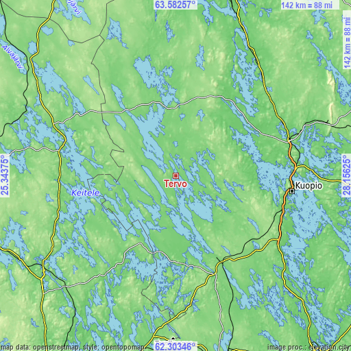
Below is the Elevation map of Tervo, which displays elevation range with different colors. Scale of the first map is from 93 to 144 m (305 to 472 ft) with average elevation of 105.7 meters (=347 ft) [note 1]
These maps also provides idea of topography and contour of this city, they are displayed at different zoom levels. More info about maps, scale and edge coordinates you can find below images.
| \ | Map #1 | Topo.Map |
| Scale [m] | 93..144 m | × |
| Scale [ft] | 305..472 ft | × |
| Average | 105.7 m = 347 ft | × |
| Width | 4.44 km = 2.8 mi | 142.2 km = 88.4 mi |
| Height | 4.44 km = 2.8 mi | 142.2 km = 88.4 mi |
| ↑Max Latitude | 62.969978° | 63.58257° |
| Latitude at center | 62.95° | 62.95° |
| ↓Min Latitude | 62.930008° | 62.30346° |
| ← Min Longitude | 26.706055° | 25.34375° |
| Longitude center | 26.75° | 26.75° |
| →Max Longitude | 26.793945° | 28.15625° |
Nearby cities:
Cities around Tervo sort by population:
• Kuopio elevation 90 m
47.4 km,  97°
97°
• Siilinjärvi 83 m
48.6 km,  72°
72°
• Suonenjoki 104 m
41.9 km,  152°
152°
• Viitasaari 142 m
46.4 km,  286°
286°
• Pielavesi 108 m
31.5 km,  0°
0°
• Rautalampi 85 m
35.5 km,  173°
173°
• Maaninka 88 m
35.9 km,  50°
50°
• Karttula 102 m
12.7 km,  118°
118°
• Konnevesi 117 m
43.1 km,  210°
210°
• Keitele 101 m
32.3 km,  323°
323°
• Vesanto 110 m
17 km,  263°
263°
• Sumiainen 84 m
48.3 km,  227°
227°
Multilingual:
 En español:
Tervo elevación 110 m.
 En France:
Tervo élévation 110 m.


Sources and notes:
- [note 1] Map square and city borders are not equal. Map elevation data is calculated only from area inside that square.
- [src 1] Elevation data from geonames database provided with same terms of usage.
- [src 2] The elevation map of Tervo is generated using GMTED2010 database with 7.5 arcsec (225m) resolution.
- [src 3] Base (background) map © OpenStreetMap contributors tiles are generated by Geofabrik and OpenTopoMap.
Copyright & License:
This Tervo Elevation Map is licensed under CC BY-SA. You may reuse any part from this page, if you give a proper credit by linking to this URL:
 More info on terms of use page.