Maaninka elevation
Maaninka (Northern Savonia, Kuopio), Finland elevation is 88 meters and Maaninka elevation in feet is 289 ft above sea level [src 1]. Maaninka is a populated place (feature code) with elevation that is 11 meters (36 ft) bigger than average city elevation in Finland.
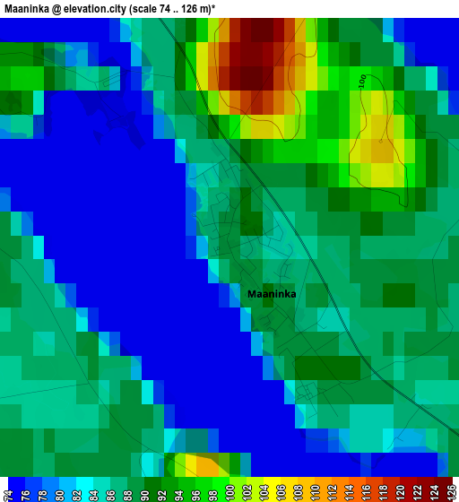
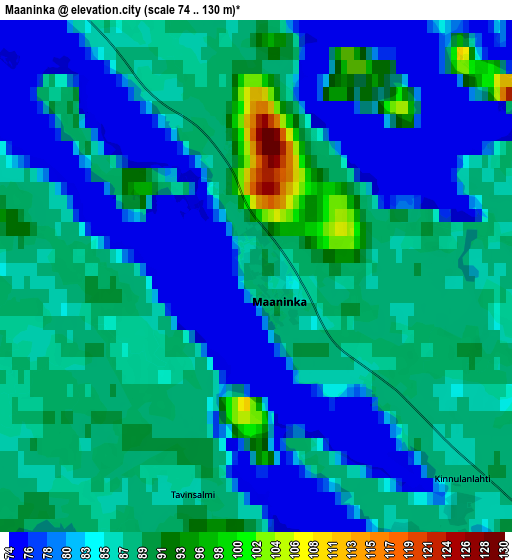
Below is the Elevation map of Maaninka, which displays elevation range with different colors. Scale of the first map is from 74 to 126 m (243 to 413 ft) with average elevation of 85.6 meters (=281 ft) [note 1]
These maps also provides idea of topography and contour of this city, they are displayed at different zoom levels. More info about maps, scale and edge coordinates you can find below images.
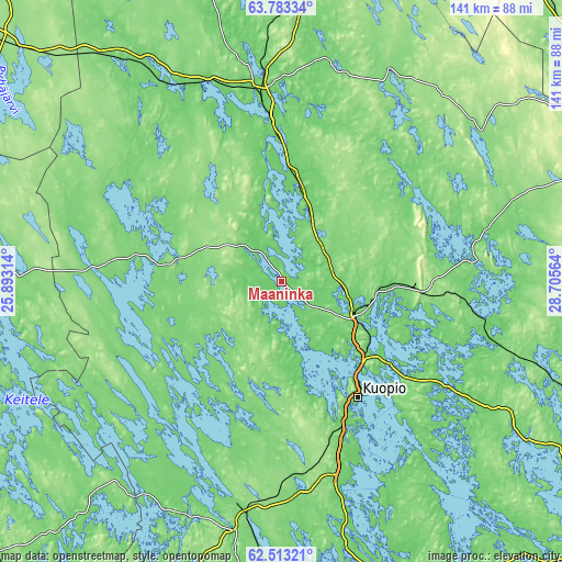
| \ | Map #1 | Map #2 | Topo.Map |
| Scale [m] | 74..126 m | 74..130 m | × |
| Scale [ft] | 243..413 ft | 243..427 ft | × |
| Average | 85.6 m = 281 ft | 84.9 m = 279 ft | × |
| Width | 4.41 km = 2.7 mi | 8.83 km = 5.5 mi | 141.2 km = 87.7 mi |
| Height | 4.41 km = 2.7 mi | 8.83 km = 5.5 mi | 141.2 km = 87.7 mi |
| ↑Max Latitude | 63.175068° | 63.194892° | 63.78334° |
| Latitude at center | 63.15523° | 63.15523° | 63.15523° |
| ↓Min Latitude | 63.135379° | 63.115514° | 62.51321° |
| ← Min Longitude | 27.255445° | 27.211499° | 25.89314° |
| Longitude center | 27.29939° | 27.29939° | 27.29939° |
| →Max Longitude | 27.343335° | 27.387281° | 28.70564° |
Nearby cities:
Cities around Maaninka sort by population:
• Kuopio elevation 90 m
34.9 km,  146°
146°
• Iisalmi 108 m
45.2 km,  353°
353°
• Siilinjärvi 83 m
20.1 km,  113°
113°
• Lapinlahti 121 m
24 km,  12°
12°
• Nilsiä 110 m
39.7 km,  81°
81°
• Pielavesi 108 m
28.9 km,  287°
287°
• Juankoski 98 m
53.7 km,  100°
100°
• Karttula 102 m
33.2 km,  209°
209°
• Varpaisjärvi 110 m
32.2 km,  45°
45°
• Keitele 101 m
46.9 km,  273°
273°
• Vesanto 110 m
50.9 km,  240°
240°
• Tervo 110 m
35.9 km,  230°
230°
Multilingual:
 En español:
Maaninka elevación 88 m.
 En France:
Maaninka élévation 88 m.


Sources and notes:
- [note 1] Map square and city borders are not equal. Map elevation data is calculated only from area inside that square.
- [src 1] Elevation data from geonames database provided with same terms of usage.
- [src 2] The elevation map of Maaninka is generated using GMTED2010 database with 7.5 arcsec (225m) resolution.
- [src 3] Base (background) map © OpenStreetMap contributors tiles are generated by Geofabrik and OpenTopoMap.
Copyright & License:
This Maaninka Elevation Map is licensed under CC BY-SA. You may reuse any part from this page, if you give a proper credit by linking to this URL:
 More info on terms of use page.