Dejen elevation
Dejen (Amhara), Ethiopia elevation is 2452 meters and Dejen elevation in feet is 8045 ft above sea level [src 1]. Dejen is a populated place (feature code) with elevation that is 556 meters (1824 ft) bigger than average city elevation in Ethiopia.
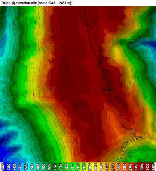
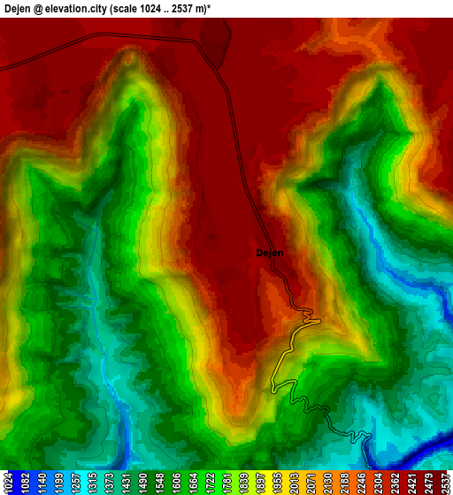
Below is the Elevation map of Dejen, which displays elevation range with different colors. Scale of the first map is from 1348 to 2481 m (4423 to 8140 ft) with average elevation of 2082.2 meters (=6831 ft) [note 1]
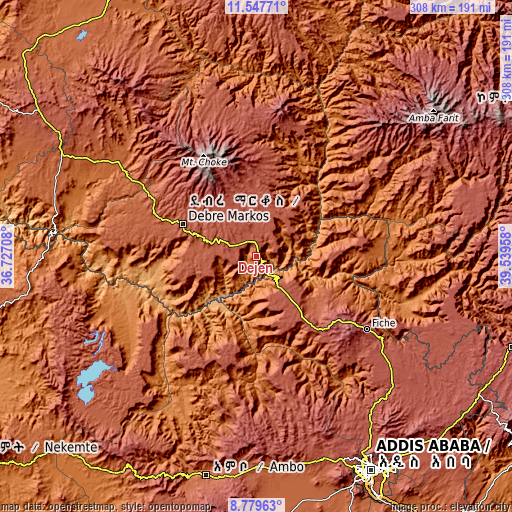
These maps also provides idea of topography and contour of this city, they are displayed at different zoom levels. More info about maps, scale and edge coordinates you can find below images.
| \ | Map #1 | Map #2 | Topo.Map |
| Scale [m] | 1348..2481 m | 1024..2537 m | × |
| Scale [ft] | 4423..8140 ft | 3360..8323 ft | × |
| Average | 2082.2 m = 6831 ft | 1905.5 m = 6252 ft | × |
| Width | 9.62 km = 6 mi | 19.24 km = 12 mi | 307.8 km = 191.3 mi |
| Height | 9.62 km = 6 mi | 19.24 km = 12 mi | 307.8 km = 191.3 mi |
| ↑Max Latitude | 10.209922° | 10.253169° | 11.54771° |
| Latitude at center | 10.16667° | 10.16667° | 10.16667° |
| ↓Min Latitude | 10.123412° | 10.080148° | 8.77963° |
| ← Min Longitude | 38.089385° | 38.045439° | 36.72708° |
| Longitude center | 38.13333° | 38.13333° | 38.13333° |
| →Max Longitude | 38.177275° | 38.221221° | 39.53958° |
Nearby cities:
Cities around Dejen sort by population:
• Debre Mark’os elevation 2487 m
48.3 km,  294°
294°
• Hāgere Hiywet 2089 m
135.2 km,  193°
193°
• Fichē 2792 m
77.3 km,  121°
121°
• Genet 2402 m
128.7 km,  161°
161°
• Finote Selam 1914 m
111.8 km,  302°
302°
• Addiet Canna 2203 m
141.4 km,  329°
329°
• Burē 2058 m
130.8 km, 296°
• Gebre Guracha 2539 m
50.1 km,  144°
144°
• Bichena 2544 m
32.3 km,  13°
13°
• Shambu 2576 m
131.4 km,  239°
239°
• Debre Werk’ 2513 m
55.7 km,  3°
3°
• Ādīs ‘Alem 2315 m
129.4 km,  166°
166°
Multilingual:
 En español:
Dejen elevación 2452 m.
 En France:
Dejen élévation 2452 m.


Sources and notes:
- [note 1] Map square and city borders are not equal. Map elevation data is calculated only from area inside that square.
- [src 1] Elevation data from geonames database provided with same terms of usage.
- [src 2] The elevation map of Dejen is generated using elevation data from NASA's 3 arcsec (90m) resolution SRTM data.
- [src 3] Base (background) map © OpenStreetMap contributors tiles are generated by Geofabrik and OpenTopoMap.
Copyright & License:
This Dejen Elevation Map is licensed under CC BY-SA. You may reuse any part from this page, if you give a proper credit by linking to this URL:
 More info on terms of use page.