Montbau elevation
Montbau (Catalonia, Província de Barcelona), Spain elevation is 250 meters and Montbau elevation in feet is 820 ft above sea level [src 1]. Montbau is a section of populated place (feature code) with elevation that is 353 meters (1158 ft) smaller than average city elevation in Spain.
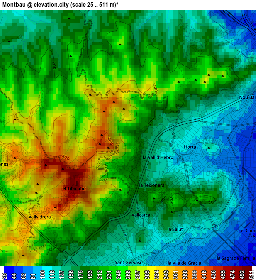
Below is the Elevation map of Montbau, which displays elevation range with different colors. Scale of the first map is from 25 to 511 m (82 to 1677 ft) with average elevation of 204.3 meters (=670 ft) [note 1]
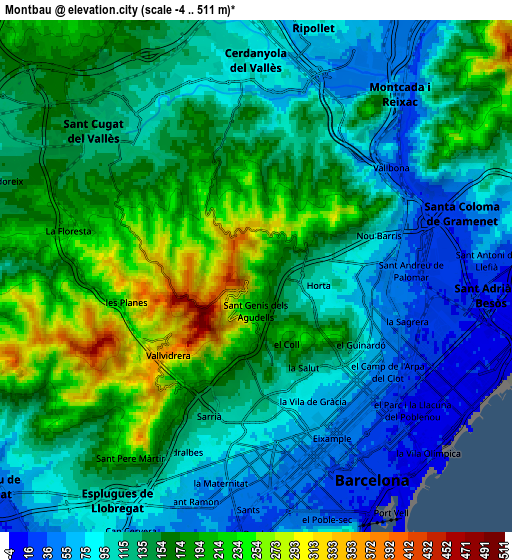
These maps also provides idea of topography and contour of this city, they are displayed at different zoom levels. More info about maps, scale and edge coordinates you can find below images.
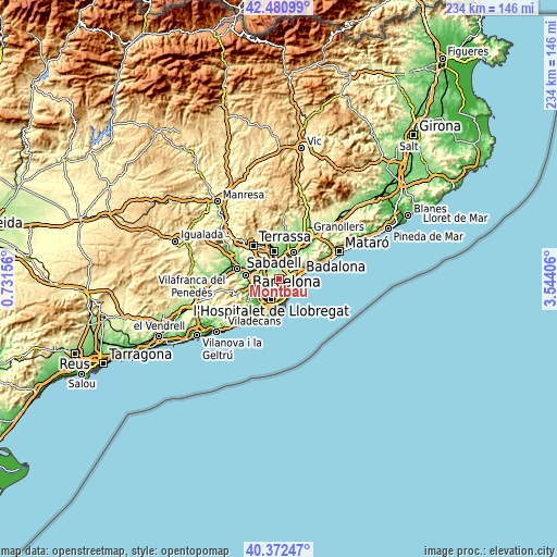
| \ | Map #1 | Map #2 | Topo.Map |
| Scale [m] | 25..511 m | -4..511 m | × |
| Scale [ft] | 82..1677 ft | -13..1677 ft | × |
| Average | 204.3 m = 670 ft | 138.9 m = 456 ft | × |
| Width | 7.33 km = 4.6 mi | 14.65 km = 9.1 mi | 234.4 km = 145.6 mi |
| Height | 7.33 km = 4.6 mi | 14.65 km = 9.1 mi | 234.4 km = 145.6 mi |
| ↑Max Latitude | 41.468228° | 41.501148° | 42.48099° |
| Latitude at center | 41.43529° | 41.43529° | 41.43529° |
| ↓Min Latitude | 41.402336° | 41.369365° | 40.37247° |
| ← Min Longitude | 2.093865° | 2.049919° | 0.73156° |
| Longitude center | 2.13781° | 2.13781° | 2.13781° |
| →Max Longitude | 2.181755° | 2.225701° | 3.54406° |
Nearby cities:
Cities around Montbau sort by population:
• El Carmel elevation 196 m
2.7 km,  137°
137°
• Horta 117 m
1.6 km,  86°
86°
• Vallcarca 120 m
2.6 km,  168°
168°
• el Turó de la Peira 94 m
2.6 km,  97°
97°
• la Guineueta 95 m
2.6 km,  81°
81°
• la Teixonera 154 m
1.5 km,  151°
151°
• la Font d'en Fargues 109 m
2.6 km,  117°
117°
• el Coll 174 m
2.2 km,  158°
158°
• Canyelles 168 m
2.4 km,  62°
62°
• Sant Genís dels Agudells 255 m
1.3 km,  210°
210°
• la Vall d'Hebron 126 m
1 km, 121°
• Can Peguera 85 m
2.4 km, 91°
Multilingual:
 En español:
Montbau elevación 250 m.
 En France:
Montbau élévation 250 m.


Sources and notes:
- [note 1] Map square and city borders are not equal. Map elevation data is calculated only from area inside that square.
- [src 1] Elevation data from geonames database provided with same terms of usage.
- [src 2] The elevation map of Montbau is generated using elevation data from NASA's 3 arcsec (90m) resolution SRTM data.
- [src 3] Base (background) map © OpenStreetMap contributors tiles are generated by Geofabrik and OpenTopoMap.
Copyright & License:
This Montbau Elevation Map is licensed under CC BY-SA. You may reuse any part from this page, if you give a proper credit by linking to this URL:
 More info on terms of use page.