el Coll elevation
el Coll (Catalonia, Província de Barcelona), Spain elevation is 174 meters and el Coll elevation in feet is 571 ft above sea level [src 1]. el Coll is a section of populated place (feature code) with elevation that is 429 meters (1407 ft) smaller than average city elevation in Spain.
Below is the Elevation map of el Coll, which displays elevation range with different colors. Scale of the first map is from 5 to 511 m (16 to 1677 ft) with average elevation of 155.7 meters (=511 ft) [note 1]
These maps also provides idea of topography and contour of this city, they are displayed at different zoom levels. More info about maps, scale and edge coordinates you can find below images.
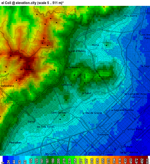
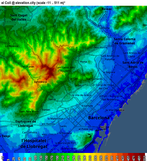
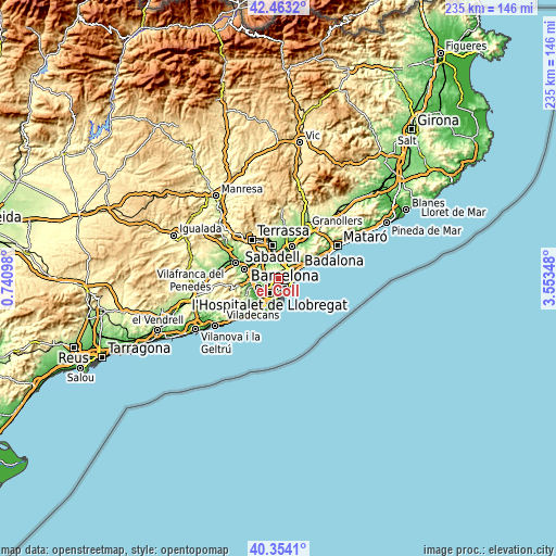
| \ | Map #1 | Map #2 | Topo.Map |
| Scale [m] | 5..511 m | -11..511 m | × |
| Scale [ft] | 16..1677 ft | -36..1677 ft | × |
| Average | 155.7 m = 511 ft | 127.5 m = 418 ft | × |
| Width | 7.33 km = 4.6 mi | 14.66 km = 9.1 mi | 234.5 km = 145.7 mi |
| Height | 7.33 km = 4.6 mi | 14.66 km = 9.1 mi | 234.5 km = 145.7 mi |
| ↑Max Latitude | 41.450157° | 41.483087° | 42.4632° |
| Latitude at center | 41.41721° | 41.41721° | 41.41721° |
| ↓Min Latitude | 41.384247° | 41.351266° | 40.3541° |
| ← Min Longitude | 2.103285° | 2.059339° | 0.74098° |
| Longitude center | 2.14723° | 2.14723° | 2.14723° |
| →Max Longitude | 2.191175° | 2.235121° | 3.55348° |
Nearby cities:
Cities around el Coll sort by population:
• Horta-Guinardó elevation 166 m
1.7 km,  85°
85°
• la Vila de Gràcia 75 m
1.8 km,  152°
152°
• El Carmel 196 m
1 km, 87°
• el Putxet i el Farró 111 m
1.2 km,  193°
193°
• el Baix Guinardó 96 m
1.8 km,  109°
109°
• Vallcarca 120 m
0.6 km,  205°
205°
• la Salut 122 m
0.8 km,  131°
131°
• la Teixonera 154 m
0.7 km,  354°
354°
• la Font d'en Fargues 109 m
1.7 km,  61°
61°
• Can Baró 155 m
1.3 km, 92°
• Sant Genís dels Agudells 255 m
1.7 km,  302°
302°
• la Vall d'Hebron 126 m
1.5 km,  3°
3°
Multilingual:
 En español:
Coll elevación 174 m.
 En France:
el Coll élévation 174 m.


Sources and notes:
- [note 1] Map square and city borders are not equal. Map elevation data is calculated only from area inside that square.
- [src 1] Elevation data from geonames database provided with same terms of usage.
- [src 2] The elevation map of el Coll is generated using elevation data from NASA's 3 arcsec (90m) resolution SRTM data.
- [src 3] Base (background) map © OpenStreetMap contributors tiles are generated by Geofabrik and OpenTopoMap.
Copyright & License:
This el Coll Elevation Map is licensed under CC BY-SA. You may reuse any part from this page, if you give a proper credit by linking to this URL:
 More info on terms of use page.