Natahoyo elevation
Natahoyo (Asturias, Province of Asturias), Spain elevation is 9 meters and Natahoyo elevation in feet is 30 ft above sea level [src 1]. Natahoyo is a populated place (feature code) with elevation that is 594 meters (1949 ft) smaller than average city elevation in Spain.
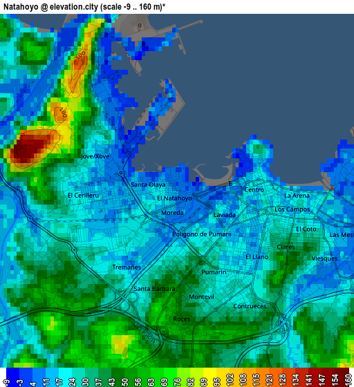
Below is the Elevation map of Natahoyo, which displays elevation range with different colors. Scale of the first map is from -9 to 160 m (-30 to 525 ft) with average elevation of 31.4 meters (=103 ft) [note 1]
These maps also provides idea of topography and contour of this city, they are displayed at different zoom levels. More info about maps, scale and edge coordinates you can find below images.
| \ | Map #1 | Map #2 | Topo.Map |
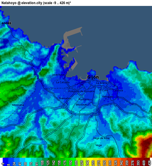
| Scale [m] | -9..160 m | -9..426 m | × |
| Scale [ft] | -30..525 ft | -30..1398 ft | × |
| Average | 31.4 m = 103 ft | 71.3 m = 234 ft | × |
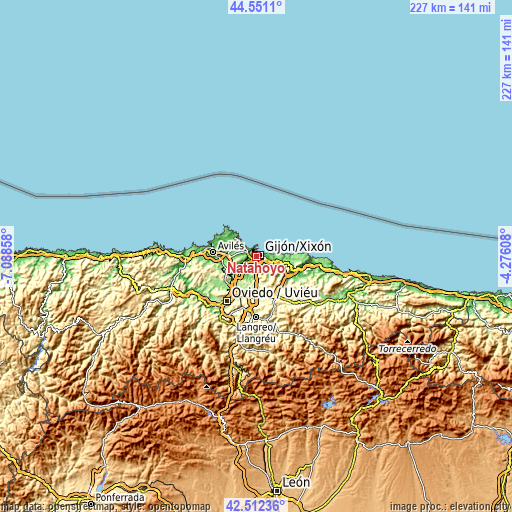
| Width | 7.08 km = 4.4 mi | 14.17 km = 8.8 mi | 226.7 km = 140.9 mi |
| Height | 7.08 km = 4.4 mi | 14.17 km = 8.8 mi | 226.7 km = 140.9 mi |
| ↑Max Latitude | 43.572197° | 43.604027° | 44.5511° |
| Latitude at center | 43.54035° | 43.54035° | 43.54035° |
| ↓Min Latitude | 43.508486° | 43.476605° | 42.51236° |
| ← Min Longitude | -5.726275° | -5.770221° | -7.08858° |
| Longitude center | -5.68233° | -5.68233° | -5.68233° |
| →Max Longitude | -5.638385° | -5.594439° | -4.27608° |
Nearby cities:
Cities around Natahoyo sort by population:
• Gijón elevation 22 m
1.8 km,  107°
107°
• Avilés 26 m
19.6 km,  274°
274°
• Corvera de Asturias 57 m
16.7 km, 268°
• Villaviciosa 6 m
20.9 km, 108°
• Lugones 169 m
18.5 km,  214°
214°
• Llanera 256 m
21.9 km,  246°
246°
• Pola de Siero 218 m
16.5 km,  174°
174°
• Luanco 13 m
12.2 km,  312°
312°
• Noreña 200 m
16.4 km,  186°
186°
• Arriba 150 m
12.2 km,  102°
102°
• Sariego 304 m
19.7 km,  142°
142°
• Llanera 161 m
20.1 km,  233°
233°
Multilingual:
 En español:
Natahoyo elevación 9 m.
 En France:
Natahoyo élévation 9 m.


Sources and notes:
- [note 1] Map square and city borders are not equal. Map elevation data is calculated only from area inside that square.
- [src 1] Elevation data from geonames database provided with same terms of usage.
- [src 2] The elevation map of Natahoyo is generated using elevation data from NASA's 3 arcsec (90m) resolution SRTM data.
- [src 3] Base (background) map © OpenStreetMap contributors tiles are generated by Geofabrik and OpenTopoMap.
Copyright & License:
This Natahoyo Elevation Map is licensed under CC BY-SA. You may reuse any part from this page, if you give a proper credit by linking to this URL:
 More info on terms of use page.