Abánades elevation
Abánades (Castille-La Mancha, Provincia de Guadalajara), Spain elevation is 1029 meters and Abánades elevation in feet is 3376 ft above sea level [src 1]. Abánades is a seat of a third-order administrative division (feature code) with elevation that is 426 meters (1398 ft) bigger than average city elevation in Spain.
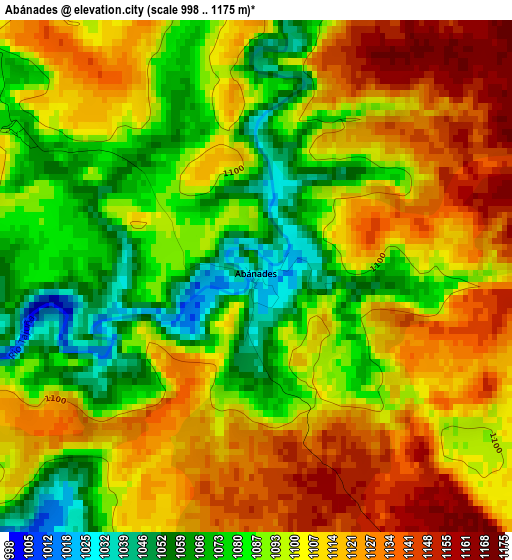
Below is the Elevation map of Abánades, which displays elevation range with different colors. Scale of the first map is from 998 to 1175 m (3274 to 3855 ft) with average elevation of 1100.2 meters (=3610 ft) [note 1]
These maps also provides idea of topography and contour of this city, they are displayed at different zoom levels. More info about maps, scale and edge coordinates you can find below images.
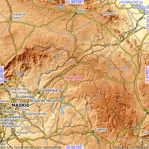
| \ | Map #1 | Topo.Map |
| Scale [m] | 998..1175 m | × |
| Scale [ft] | 3274..3855 ft | × |
| Average | 1100.2 m = 3610 ft | × |
| Width | 7.39 km = 4.6 mi | 236.4 km = 146.9 mi |
| Height | 7.39 km = 4.6 mi | 236.4 km = 146.9 mi |
| ↑Max Latitude | 40.925822° | 41.94709° |
| Latitude at center | 40.89261° | 40.89261° |
| ↓Min Latitude | 40.859382° | 39.82105° |
| ← Min Longitude | -2.529205° | -3.89151° |
| Longitude center | -2.48526° | -2.48526° |
| →Max Longitude | -2.441315° | -1.07901° |
Nearby cities:
Cities around Abánades sort by population:
• Torremocha del Campo elevation 1088 m
14.7 km,  310°
310°
• Riba de Saelices 984 m
15.9 km,  82°
82°
• Sacecorbo 1120 m
8.7 km,  139°
139°
• Canredondo 1164 m
8.9 km,  184°
184°
• Luzaga 1076 m
9.6 km,  20°
20°
• Saúca 1103 m
15.8 km,  346°
346°
• Saelices de la Sal 1001 m
13.7 km, 83°
• Sotodosos 1152 m
8.5 km,  67°
67°
• Esplegares 1154 m
10.4 km,  112°
112°
• Torrecuadradilla 1022 m
5.9 km,  222°
222°
• Ocentejo 865 m
15.3 km,  151°
151°
• Iniéstola 1166 m
14.8 km,  40°
40°
Multilingual:
 En español:
Abánades elevación 1029 m.
 En France:
Abánades élévation 1029 m.
 Auf Deutsch:
Abánades höhe über dem Meeresspiegel ist 1029 m.

Sources and notes:
- [note 1] Map square and city borders are not equal. Map elevation data is calculated only from area inside that square.
- [src 1] Elevation data from geonames database provided with same terms of usage.
- [src 2] The elevation map of Abánades is generated using elevation data from NASA's 3 arcsec (90m) resolution SRTM data.
- [src 3] Base (background) map © OpenStreetMap contributors tiles are generated by Geofabrik and OpenTopoMap.
Copyright & License:
This Abánades Elevation Map is licensed under CC BY-SA. You may reuse any part from this page, if you give a proper credit by linking to this URL:
 More info on terms of use page.