Adradas elevation
Adradas (Castille and León, Provincia de Soria), Spain elevation is 1056 meters and Adradas elevation in feet is 3465 ft above sea level [src 1]. Adradas is a seat of a third-order administrative division (feature code) with elevation that is 453 meters (1486 ft) bigger than average city elevation in Spain.
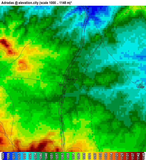
Below is the Elevation map of Adradas, which displays elevation range with different colors. Scale of the first map is from 1000 to 1148 m (3281 to 3766 ft) with average elevation of 1057.3 meters (=3469 ft) [note 1]
These maps also provides idea of topography and contour of this city, they are displayed at different zoom levels. More info about maps, scale and edge coordinates you can find below images.
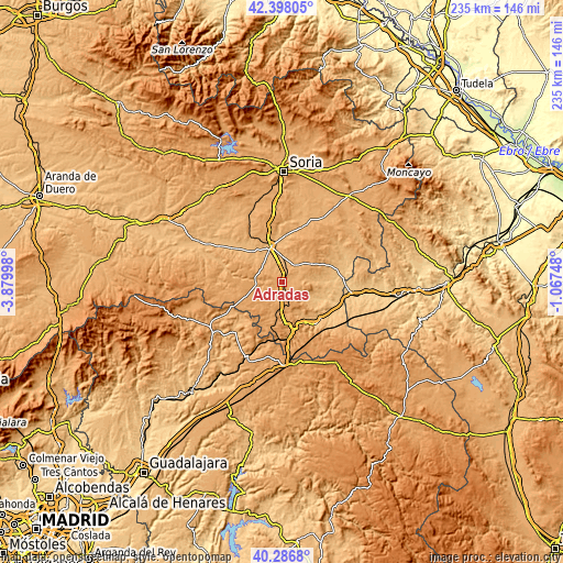
| \ | Map #1 | Topo.Map |
| Scale [m] | 1000..1148 m | × |
| Scale [ft] | 3281..3766 ft | × |
| Average | 1057.3 m = 3469 ft | × |
| Width | 7.34 km = 4.6 mi | 234.7 km = 145.8 mi |
| Height | 7.34 km = 4.6 mi | 234.7 km = 145.8 mi |
| ↑Max Latitude | 41.38396° | 42.39805° |
| Latitude at center | 41.35098° | 41.35098° |
| ↓Min Latitude | 41.317983° | 40.2868° |
| ← Min Longitude | -2.517675° | -3.87998° |
| Longitude center | -2.47373° | -2.47373° |
| →Max Longitude | -2.429785° | -1.06748° |
Nearby cities:
Cities around Adradas sort by population:
• Almazán elevation 948 m
15.8 km,  342°
342°
• Morón de Almazán 996 m
8.6 km,  35°
35°
• Coscurita 965 m
9.3 km,  358°
358°
• Barca 967 m
16.9 km,  313°
313°
• Villasayas 1028 m
11.4 km,  271°
271°
• Alcubilla de las Peñas 1132 m
11.9 km,  201°
201°
• Taroda 1030 m
3.4 km,  95°
95°
• Yelo 1130 m
15.4 km,  193°
193°
• Alentisque 1064 m
14.1 km,  56°
56°
• Soliedra 1102 m
15.2 km,  30°
30°
• Momblona 1064 m
14.8 km,  45°
45°
• Frechilla de Almazán 985 m
9.1 km, 337°
Multilingual:
 En español:
Adradas elevación 1056 m.
 En France:
Adradas élévation 1056 m.
 Auf Deutsch:
Adradas höhe über dem Meeresspiegel ist 1056 m.

Sources and notes:
- [note 1] Map square and city borders are not equal. Map elevation data is calculated only from area inside that square.
- [src 1] Elevation data from geonames database provided with same terms of usage.
- [src 2] The elevation map of Adradas is generated using elevation data from NASA's 3 arcsec (90m) resolution SRTM data.
- [src 3] Base (background) map © OpenStreetMap contributors tiles are generated by Geofabrik and OpenTopoMap.
Copyright & License:
This Adradas Elevation Map is licensed under CC BY-SA. You may reuse any part from this page, if you give a proper credit by linking to this URL:
 More info on terms of use page.