Almazán elevation
Almazán (Castille and León, Provincia de Soria), Spain elevation is 948 meters and Almazán elevation in feet is 3110 ft above sea level [src 1]. Almazán is a seat of a third-order administrative division (feature code) with elevation that is 345 meters (1132 ft) bigger than average city elevation in Spain.
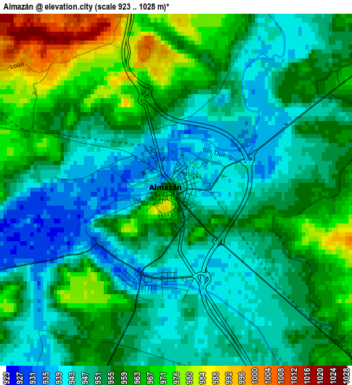
Below is the Elevation map of Almazán, which displays elevation range with different colors. Scale of the first map is from 923 to 1028 m (3028 to 3373 ft) with average elevation of 955.2 meters (=3134 ft) [note 1]
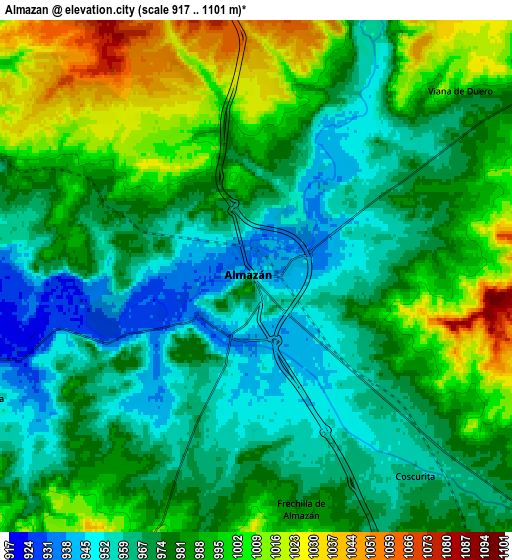
These maps also provides idea of topography and contour of this city, they are displayed at different zoom levels. More info about maps, scale and edge coordinates you can find below images.
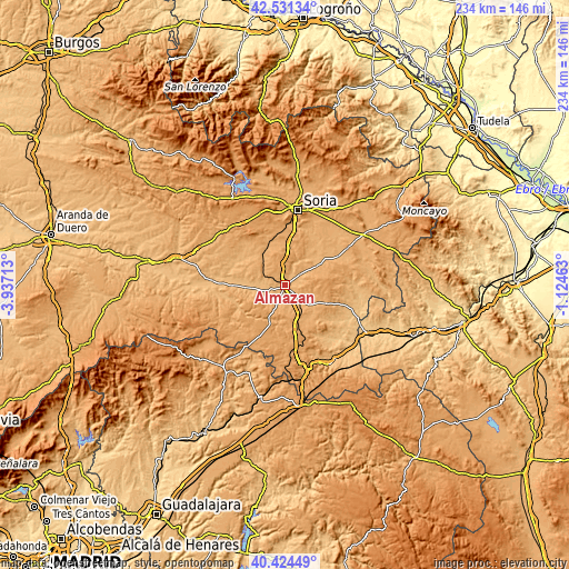
| \ | Map #1 | Map #2 | Topo.Map |
| Scale [m] | 923..1028 m | 917..1101 m | × |
| Scale [ft] | 3028..3373 ft | 3009..3612 ft | × |
| Average | 955.2 m = 3134 ft | 980.3 m = 3216 ft | × |
| Width | 7.32 km = 4.5 mi | 14.64 km = 9.1 mi | 234.3 km = 145.6 mi |
| Height | 7.32 km = 4.5 mi | 14.64 km = 9.1 mi | 234.3 km = 145.6 mi |
| ↑Max Latitude | 41.519392° | 41.552286° | 42.53134° |
| Latitude at center | 41.48648° | 41.48648° | 41.48648° |
| ↓Min Latitude | 41.453552° | 41.420607° | 40.42449° |
| ← Min Longitude | -2.574825° | -2.618771° | -3.93713° |
| Longitude center | -2.53088° | -2.53088° | -2.53088° |
| →Max Longitude | -2.486935° | -2.442989° | -1.12463° |
Nearby cities:
Cities around Almazán sort by population:
• Tardelcuende elevation 990 m
15.2 km,  321°
321°
• Matamala de Almazán 950 m
9.4 km,  283°
283°
• Morón de Almazán 996 m
12.7 km,  129°
129°
• Coscurita 965 m
7.4 km,  141°
141°
• Velamazán 980 m
14.6 km,  253°
253°
• Barca 967 m
8.4 km, 245°
• Nepas 1047 m
11.9 km,  68°
68°
• Viana de Duero 1000 m
7.9 km,  47°
47°
• Borjabad 1011 m
15.5 km,  61°
61°
• Soliedra 1102 m
12.6 km,  98°
98°
• Escobosa de Almazán 1086 m
13.3 km,  90°
90°
• Frechilla de Almazán 985 m
6.8 km,  168°
168°
Multilingual:
 En español:
Almazán elevación 948 m.
 En France:
Almazán élévation 948 m.


Sources and notes:
- [note 1] Map square and city borders are not equal. Map elevation data is calculated only from area inside that square.
- [src 1] Elevation data from geonames database provided with same terms of usage.
- [src 2] The elevation map of Almazán is generated using elevation data from NASA's 3 arcsec (90m) resolution SRTM data.
- [src 3] Base (background) map © OpenStreetMap contributors tiles are generated by Geofabrik and OpenTopoMap.
Copyright & License:
This Almazán Elevation Map is licensed under CC BY-SA. You may reuse any part from this page, if you give a proper credit by linking to this URL:
 More info on terms of use page.