Agallas elevation
Agallas (Castille and León, Provincia de Salamanca), Spain elevation is 802 meters and Agallas elevation in feet is 2631 ft above sea level [src 1]. Agallas is a seat of a third-order administrative division (feature code) with elevation that is 199 meters (653 ft) bigger than average city elevation in Spain.
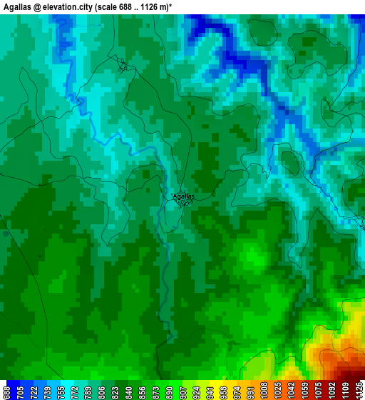
Below is the Elevation map of Agallas, which displays elevation range with different colors. Scale of the first map is from 688 to 1126 m (2257 to 3694 ft) with average elevation of 817 meters (=2680 ft) [note 1]
These maps also provides idea of topography and contour of this city, they are displayed at different zoom levels. More info about maps, scale and edge coordinates you can find below images.
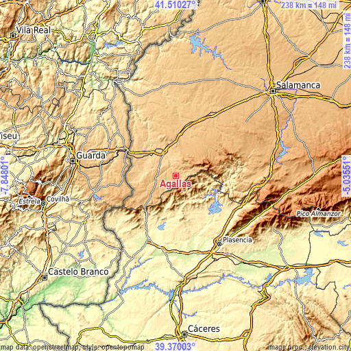
| \ | Map #1 | Topo.Map |
| Scale [m] | 688..1126 m | × |
| Scale [ft] | 2257..3694 ft | × |
| Average | 817 m = 2680 ft | × |
| Width | 7.44 km = 4.6 mi | 238 km = 147.9 mi |
| Height | 7.44 km = 4.6 mi | 238 km = 147.9 mi |
| ↑Max Latitude | 40.482104° | 41.51027° |
| Latitude at center | 40.44867° | 40.44867° |
| ↓Min Latitude | 40.41522° | 39.37003° |
| ← Min Longitude | -6.485705° | -7.84801° |
| Longitude center | -6.44176° | -6.44176° |
| →Max Longitude | -6.397815° | -5.03551° |
Nearby cities:
Cities around Agallas sort by population:
• Nuñomoral elevation 502 m
17.2 km,  105°
105°
• Casares de las Hurdes 591 m
13.5 km,  97°
97°
• Robleda 839 m
15.7 km,  243°
243°
• Serradilla del Arroyo 855 m
10.6 km,  40°
40°
• Martiago 812 m
4.1 km,  278°
278°
• Descargamaría 506 m
16.5 km,  193°
193°
• Serradilla del Llano 877 m
9.2 km,  51°
51°
• Monsagro 956 m
15.7 km,  67°
67°
• Herguijuela de Ciudad Rodrigo 793 m
6.8 km, 279°
• Robledillo de Gata 575 m
14.3 km, 190°
• Zamarra 781 m
7.9 km,  353°
353°
• Pastores 767 m
9.4 km,  321°
321°
Multilingual:
 En español:
Agallas elevación 802 m.
 En France:
Agallas élévation 802 m.


Sources and notes:
- [note 1] Map square and city borders are not equal. Map elevation data is calculated only from area inside that square.
- [src 1] Elevation data from geonames database provided with same terms of usage.
- [src 2] The elevation map of Agallas is generated using elevation data from NASA's 3 arcsec (90m) resolution SRTM data.
- [src 3] Base (background) map © OpenStreetMap contributors tiles are generated by Geofabrik and OpenTopoMap.
Copyright & License:
This Agallas Elevation Map is licensed under CC BY-SA. You may reuse any part from this page, if you give a proper credit by linking to this URL:
 More info on terms of use page.