Descargamaría elevation
Descargamaría (Extremadura, Provincia de Cáceres), Spain elevation is 506 meters and Descargamaría elevation in feet is 1660 ft above sea level [src 1]. Descargamaría is a seat of a third-order administrative division (feature code) with elevation that is 97 meters (318 ft) smaller than average city elevation in Spain.
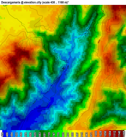
Below is the Elevation map of Descargamaría, which displays elevation range with different colors. Scale of the first map is from 438 to 1168 m (1437 to 3832 ft) with average elevation of 761.4 meters (=2498 ft) [note 1]
These maps also provides idea of topography and contour of this city, they are displayed at different zoom levels. More info about maps, scale and edge coordinates you can find below images.
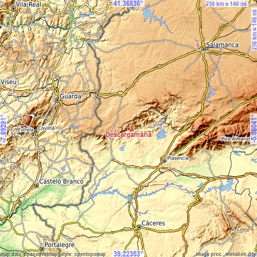
| \ | Map #1 | Topo.Map |
| Scale [m] | 438..1168 m | × |
| Scale [ft] | 1437..3832 ft | × |
| Average | 761.4 m = 2498 ft | × |
| Width | 7.45 km = 4.6 mi | 238.5 km = 148.2 mi |
| Height | 7.45 km = 4.6 mi | 238.5 km = 148.2 mi |
| ↑Max Latitude | 40.337965° | 41.36836° |
| Latitude at center | 40.30446° | 40.30446° |
| ↓Min Latitude | 40.270938° | 39.22353° |
| ← Min Longitude | -6.530605° | -7.89291° |
| Longitude center | -6.48666° | -6.48666° |
| →Max Longitude | -6.442715° | -5.08041° |
Nearby cities:
Cities around Descargamaría sort by population:
• Gata elevation 642 m
11.9 km,  231°
231°
• Pinofranqueado 466 m
13.1 km,  90°
90°
• Torrecilla de los Ángeles 453 m
8.7 km,  136°
136°
• Torre de Don Miguel 558 m
11.8 km,  220°
220°
• Villanueva de la Sierra 503 m
13.3 km,  149°
149°
• Cadalso 439 m
8.8 km,  211°
211°
• Robleda 839 m
13.6 km,  311°
311°
• Hernán-Pérez 442 m
10.4 km,  169°
169°
• Santibáñez el Alto 648 m
14.2 km,  201°
201°
• Peñaparda 866 m
15.6 km,  276°
276°
• Villasrubias 856 m
13.5 km,  286°
286°
• Robledillo de Gata 575 m
2.4 km,  33°
33°
Multilingual:
 En español:
Descargamaría elevación 506 m.
 En France:
Descargamaría élévation 506 m.
 Auf Deutsch:
Descargamaría höhe über dem Meeresspiegel ist 506 m.

Sources and notes:
- [note 1] Map square and city borders are not equal. Map elevation data is calculated only from area inside that square.
- [src 1] Elevation data from geonames database provided with same terms of usage.
- [src 2] The elevation map of Descargamaría is generated using elevation data from NASA's 3 arcsec (90m) resolution SRTM data.
- [src 3] Base (background) map © OpenStreetMap contributors tiles are generated by Geofabrik and OpenTopoMap.
Copyright & License:
This Descargamaría Elevation Map is licensed under CC BY-SA. You may reuse any part from this page, if you give a proper credit by linking to this URL:
 More info on terms of use page.