Cadalso elevation
Cadalso (Extremadura, Provincia de Cáceres), Spain elevation is 439 meters and Cadalso elevation in feet is 1440 ft above sea level [src 1]. Cadalso is a seat of a third-order administrative division (feature code) with elevation that is 164 meters (538 ft) smaller than average city elevation in Spain.
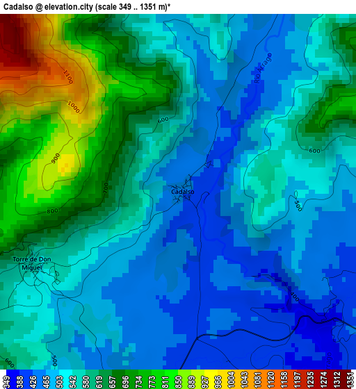
Below is the Elevation map of Cadalso, which displays elevation range with different colors. Scale of the first map is from 349 to 1351 m (1145 to 4432 ft) with average elevation of 569.5 meters (=1868 ft) [note 1]
These maps also provides idea of topography and contour of this city, they are displayed at different zoom levels. More info about maps, scale and edge coordinates you can find below images.
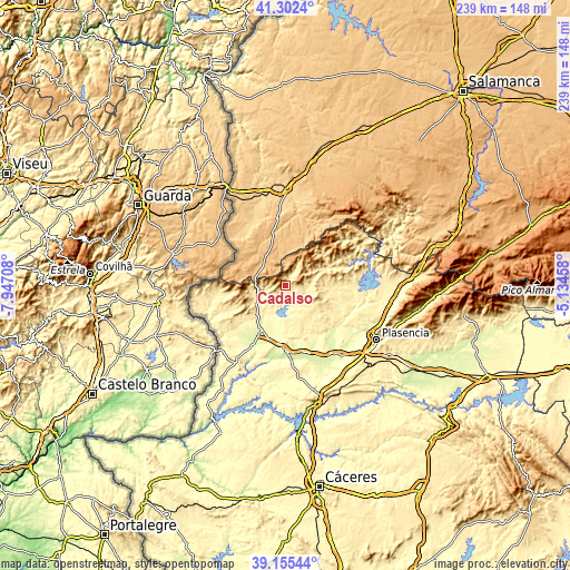
| \ | Map #1 | Topo.Map |
| Scale [m] | 349..1351 m | × |
| Scale [ft] | 1145..4432 ft | × |
| Average | 569.5 m = 1868 ft | × |
| Width | 7.46 km = 4.6 mi | 238.7 km = 148.3 mi |
| Height | 7.46 km = 4.6 mi | 238.7 km = 148.3 mi |
| ↑Max Latitude | 40.270968° | 41.3024° |
| Latitude at center | 40.23743° | 40.23743° |
| ↓Min Latitude | 40.203875° | 39.15544° |
| ← Min Longitude | -6.584775° | -7.94708° |
| Longitude center | -6.54083° | -6.54083° |
| →Max Longitude | -6.496885° | -5.13458° |
Nearby cities:
Cities around Cadalso sort by population:
• Gata elevation 642 m
4.8 km,  270°
270°
• Torrecilla de los Ángeles 453 m
10.7 km,  83°
83°
• Villa del Campo 476 m
14.3 km,  137°
137°
• Torre de Don Miguel 558 m
3.4 km,  242°
242°
• Villanueva de la Sierra 503 m
12.1 km,  109°
109°
• Hernán-Pérez 442 m
7 km, 113°
• Villasbuenas de Gata 423 m
9.8 km,  228°
228°
• Santibáñez el Alto 648 m
5.8 km,  185°
185°
• Peñaparda 866 m
14.3 km,  310°
310°
• Descargamaría 506 m
8.8 km,  31°
31°
• Villasrubias 856 m
14 km,  323°
323°
• Robledillo de Gata 575 m
11.1 km, 31°
Multilingual:
 En español:
Cadalso elevación 439 m.
 En France:
Cadalso élévation 439 m.


Sources and notes:
- [note 1] Map square and city borders are not equal. Map elevation data is calculated only from area inside that square.
- [src 1] Elevation data from geonames database provided with same terms of usage.
- [src 2] The elevation map of Cadalso is generated using elevation data from NASA's 3 arcsec (90m) resolution SRTM data.
- [src 3] Base (background) map © OpenStreetMap contributors tiles are generated by Geofabrik and OpenTopoMap.
Copyright & License:
This Cadalso Elevation Map is licensed under CC BY-SA. You may reuse any part from this page, if you give a proper credit by linking to this URL:
 More info on terms of use page.