Aguilar de Campoo elevation
Aguilar de Campoo (Castille and León, Provincia de Palencia), Spain elevation is 904 meters and Aguilar de Campoo elevation in feet is 2966 ft above sea level [src 1]. Aguilar de Campoo is a seat of a third-order administrative division (feature code) with elevation that is 301 meters (988 ft) bigger than average city elevation in Spain.
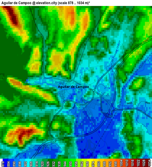
Below is the Elevation map of Aguilar de Campoo, which displays elevation range with different colors. Scale of the first map is from 878 to 1034 m (2881 to 3392 ft) with average elevation of 925.8 meters (=3037 ft) [note 1]
These maps also provides idea of topography and contour of this city, they are displayed at different zoom levels. More info about maps, scale and edge coordinates you can find below images.
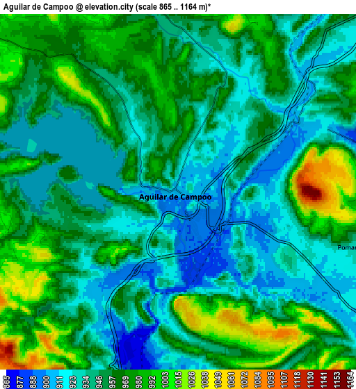
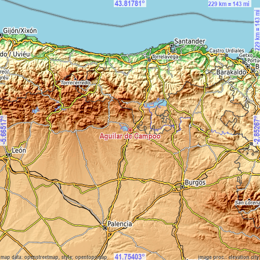
| \ | Map #1 | Map #2 | Topo.Map |
| Scale [m] | 878..1034 m | 865..1164 m | × |
| Scale [ft] | 2881..3392 ft | 2838..3819 ft | × |
| Average | 925.8 m = 3037 ft | 952.8 m = 3126 ft | × |
| Width | 7.17 km = 4.5 mi | 14.34 km = 8.9 mi | 229.5 km = 142.6 mi |
| Height | 7.17 km = 4.5 mi | 14.34 km = 8.9 mi | 229.5 km = 142.6 mi |
| ↑Max Latitude | 42.826758° | 42.85898° | 43.81781° |
| Latitude at center | 42.79452° | 42.79452° | 42.79452° |
| ↓Min Latitude | 42.762265° | 42.729993° | 41.75403° |
| ← Min Longitude | -4.302865° | -4.346811° | -5.66517° |
| Longitude center | -4.25892° | -4.25892° | -4.25892° |
| →Max Longitude | -4.214975° | -4.171029° | -2.85267° |
Nearby cities:
Cities around Aguilar de Campoo sort by population:
• Barruelo de Santullán elevation 1069 m
12.6 km,  349°
349°
• Mataporquera 927 m
11.9 km,  41°
41°
• Alar del Rey 852 m
15.5 km,  196°
196°
• Pomar de Valdivia 940 m
7.8 km,  106°
106°
• Salinas de Pisuerga 948 m
11.5 km,  302°
302°
• Olmos de Ojeda 923 m
15.7 km,  239°
239°
• Brañosera 1218 m
16.3 km, 345°
• Prádanos de Ojeda 933 m
14.5 km,  209°
209°
• San Cebrián de Mudá 1042 m
15.1 km,  316°
316°
• Rebolledo de la Torre 956 m
12 km,  167°
167°
• Mudá 994 m
14.2 km,  309°
309°
• Santibáñez de Ecla 952 m
13.4 km,  223°
223°
Multilingual:
 En español:
Aguilar de Campoo elevación 904 m.
 En France:
Aguilar de Campoo élévation 904 m.
 Auf Deutsch:
Aguilar de Campoo höhe über dem Meeresspiegel ist 904 m.

Sources and notes:
- [note 1] Map square and city borders are not equal. Map elevation data is calculated only from area inside that square.
- [src 1] Elevation data from geonames database provided with same terms of usage.
- [src 2] The elevation map of Aguilar de Campoo is generated using elevation data from NASA's 3 arcsec (90m) resolution SRTM data.
- [src 3] Base (background) map © OpenStreetMap contributors tiles are generated by Geofabrik and OpenTopoMap.
Copyright & License:
This Aguilar de Campoo Elevation Map is licensed under CC BY-SA. You may reuse any part from this page, if you give a proper credit by linking to this URL:
 More info on terms of use page.