Brañosera elevation
Brañosera (Castille and León, Provincia de Palencia), Spain elevation is 1218 meters and Brañosera elevation in feet is 3996 ft above sea level [src 1]. Brañosera is a seat of a third-order administrative division (feature code) with elevation that is 615 meters (2018 ft) bigger than average city elevation in Spain.
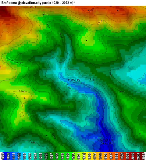
Below is the Elevation map of Brañosera, which displays elevation range with different colors. Scale of the first map is from 1029 to 2092 m (3376 to 6864 ft) with average elevation of 1428.9 meters (=4688 ft) [note 1]
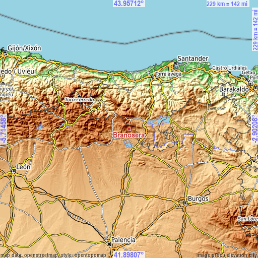
These maps also provides idea of topography and contour of this city, they are displayed at different zoom levels. More info about maps, scale and edge coordinates you can find below images.
| \ | Map #1 | Topo.Map |
| Scale [m] | 1029..2092 m | × |
| Scale [ft] | 3376..6864 ft | × |
| Average | 1428.9 m = 4688 ft | × |
| Width | 7.15 km = 4.4 mi | 228.9 km = 142.2 mi |
| Height | 7.15 km = 4.4 mi | 228.9 km = 142.2 mi |
| ↑Max Latitude | 42.968365° | 43.95712° |
| Latitude at center | 42.9362° | 42.9362° |
| ↓Min Latitude | 42.904019° | 41.89807° |
| ← Min Longitude | -4.352275° | -5.71458° |
| Longitude center | -4.30833° | -4.30833° |
| →Max Longitude | -4.264385° | -2.90208° |
Nearby cities:
Cities around Brañosera sort by population:
• Reinosa elevation 852 m
15.5 km,  63°
63°
• Aguilar de Campoo 904 m
16.3 km,  165°
165°
• Villaescusa 875 m
11.9 km,  75°
75°
• Cervera de Pisuerga 1003 m
17.3 km,  243°
243°
• Barruelo de Santullán 1069 m
3.8 km,  151°
151°
• Mataporquera 927 m
13.7 km,  119°
119°
• Ruesga 1044 m
19.7 km,  246°
246°
• Salinas de Pisuerga 948 m
11.1 km,  210°
210°
• Dehesa de Montejo 1095 m
21 km,  231°
231°
• San Cebrián de Mudá 1042 m
8 km, 232°
• Mudá 994 m
9.7 km, 225°
• Polentinos 1272 m
18 km,  271°
271°
Multilingual:
 En español:
Brañosera elevación 1218 m.
 En France:
Brañosera élévation 1218 m.
 Auf Deutsch:
Brañosera höhe über dem Meeresspiegel ist 1218 m.

Sources and notes:
- [note 1] Map square and city borders are not equal. Map elevation data is calculated only from area inside that square.
- [src 1] Elevation data from geonames database provided with same terms of usage.
- [src 2] The elevation map of Brañosera is generated using elevation data from NASA's 3 arcsec (90m) resolution SRTM data.
- [src 3] Base (background) map © OpenStreetMap contributors tiles are generated by Geofabrik and OpenTopoMap.
Copyright & License:
This Brañosera Elevation Map is licensed under CC BY-SA. You may reuse any part from this page, if you give a proper credit by linking to this URL:
 More info on terms of use page.