Aladrén elevation
Aladrén (Aragon, Provincia de Zaragoza), Spain elevation is 779 meters and Aladrén elevation in feet is 2556 ft above sea level [src 1]. Aladrén is a seat of a third-order administrative division (feature code) with elevation that is 176 meters (577 ft) bigger than average city elevation in Spain.
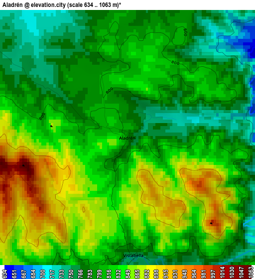
Below is the Elevation map of Aladrén, which displays elevation range with different colors. Scale of the first map is from 634 to 1063 m (2080 to 3488 ft) with average elevation of 817.2 meters (=2681 ft) [note 1]
These maps also provides idea of topography and contour of this city, they are displayed at different zoom levels. More info about maps, scale and edge coordinates you can find below images.
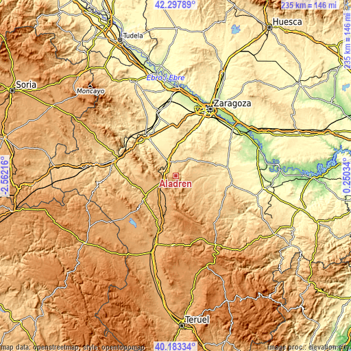
| \ | Map #1 | Topo.Map |
| Scale [m] | 634..1063 m | × |
| Scale [ft] | 2080..3488 ft | × |
| Average | 817.2 m = 2681 ft | × |
| Width | 7.35 km = 4.6 mi | 235.1 km = 146.1 mi |
| Height | 7.35 km = 4.6 mi | 235.1 km = 146.1 mi |
| ↑Max Latitude | 41.282202° | 42.29789° |
| Latitude at center | 41.24917° | 41.24917° |
| ↓Min Latitude | 41.216121° | 40.18334° |
| ← Min Longitude | -1.199855° | -2.56216° |
| Longitude center | -1.15591° | -1.15591° |
| →Max Longitude | -1.111965° | 0.25034° |
Nearby cities:
Cities around Aladrén sort by population:
• Cariñena elevation 599 m
11.4 km,  329°
329°
• Paniza 711 m
6.1 km,  309°
309°
• Herrera de los Navarros 812 m
7.5 km,  125°
125°
• Aguilón 687 m
10.5 km,  61°
61°
• Encinacorba 754 m
10.7 km,  291°
291°
• Tosos 612 m
10.1 km,  43°
43°
• Villarreal de Huerva 871 m
13 km,  239°
239°
• Villar de los Navarros 795 m
13.8 km,  136°
136°
• Luesma 948 m
9.3 km,  174°
174°
• Vistabella 744 m
3.4 km,  176°
176°
• Cerveruela 812 m
6.2 km,  233°
233°
• Fombuena 1018 m
12 km,  194°
194°
Multilingual:
 En español:
Aladrén elevación 779 m.
 En France:
Aladrén élévation 779 m.


Sources and notes:
- [note 1] Map square and city borders are not equal. Map elevation data is calculated only from area inside that square.
- [src 1] Elevation data from geonames database provided with same terms of usage.
- [src 2] The elevation map of Aladrén is generated using elevation data from NASA's 3 arcsec (90m) resolution SRTM data.
- [src 3] Base (background) map © OpenStreetMap contributors tiles are generated by Geofabrik and OpenTopoMap.
Copyright & License:
This Aladrén Elevation Map is licensed under CC BY-SA. You may reuse any part from this page, if you give a proper credit by linking to this URL:
 More info on terms of use page.