Fombuena elevation
Fombuena (Aragon, Provincia de Zaragoza), Spain elevation is 1018 meters and Fombuena elevation in feet is 3340 ft above sea level [src 1]. Fombuena is a seat of a third-order administrative division (feature code) with elevation that is 415 meters (1362 ft) bigger than average city elevation in Spain.
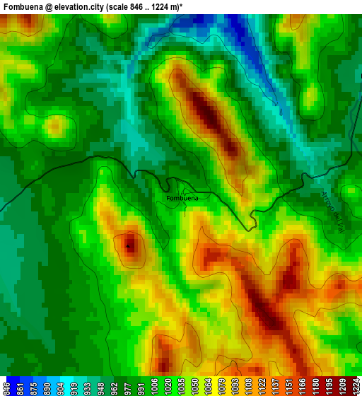
Below is the Elevation map of Fombuena, which displays elevation range with different colors. Scale of the first map is from 846 to 1224 m (2776 to 4016 ft) with average elevation of 1017.6 meters (=3339 ft) [note 1]
These maps also provides idea of topography and contour of this city, they are displayed at different zoom levels. More info about maps, scale and edge coordinates you can find below images.
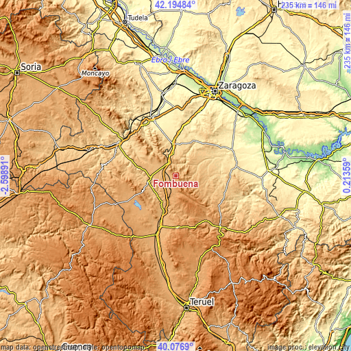
| \ | Map #1 | Topo.Map |
| Scale [m] | 846..1224 m | × |
| Scale [ft] | 2776..4016 ft | × |
| Average | 1017.6 m = 3339 ft | × |
| Width | 7.36 km = 4.6 mi | 235.5 km = 146.3 mi |
| Height | 7.36 km = 4.6 mi | 235.5 km = 146.3 mi |
| ↑Max Latitude | 41.177505° | 42.19484° |
| Latitude at center | 41.14442° | 41.14442° |
| ↓Min Latitude | 41.111318° | 40.0769° |
| ← Min Longitude | -1.236605° | -2.59891° |
| Longitude center | -1.19266° | -1.19266° |
| →Max Longitude | -1.148715° | 0.21359° |
Nearby cities:
Cities around Fombuena sort by population:
• Villarreal de Huerva elevation 871 m
9.6 km,  302°
302°
• Romanos 948 m
7.2 km,  253°
253°
• Villahermosa del Campo 962 m
6 km,  229°
229°
• Badules 920 m
5.1 km,  263°
263°
• Villadoz 893 m
8.2 km,  284°
284°
• Cucalón 1035 m
6.7 km,  195°
195°
• Luesma 948 m
4.6 km,  58°
58°
• Vistabella 744 m
8.9 km,  21°
21°
• Cerveruela 812 m
8.1 km,  346°
346°
• Santa Cruz de Nogueras 894 m
9.3 km,  110°
110°
• Lanzuela 1013 m
5.2 km,  192°
192°
• Bádenas 1007 m
8.3 km,  134°
134°
Multilingual:
 En español:
Fombuena elevación 1018 m.
 En France:
Fombuena élévation 1018 m.
 Auf Deutsch:
Fombuena höhe über dem Meeresspiegel ist 1018 m.

Sources and notes:
- [note 1] Map square and city borders are not equal. Map elevation data is calculated only from area inside that square.
- [src 1] Elevation data from geonames database provided with same terms of usage.
- [src 2] The elevation map of Fombuena is generated using elevation data from NASA's 3 arcsec (90m) resolution SRTM data.
- [src 3] Base (background) map © OpenStreetMap contributors tiles are generated by Geofabrik and OpenTopoMap.
Copyright & License:
This Fombuena Elevation Map is licensed under CC BY-SA. You may reuse any part from this page, if you give a proper credit by linking to this URL:
 More info on terms of use page.