Alaejos elevation
Alaejos (Castille and León, Provincia de Valladolid), Spain elevation is 755 meters and Alaejos elevation in feet is 2477 ft above sea level [src 1]. Alaejos is a seat of a third-order administrative division (feature code) with elevation that is 152 meters (499 ft) bigger than average city elevation in Spain.
Below is the Elevation map of Alaejos, which displays elevation range with different colors. Scale of the first map is from 717 to 789 m (2352 to 2589 ft) with average elevation of 754.8 meters (=2476 ft) [note 1]
These maps also provides idea of topography and contour of this city, they are displayed at different zoom levels. More info about maps, scale and edge coordinates you can find below images.
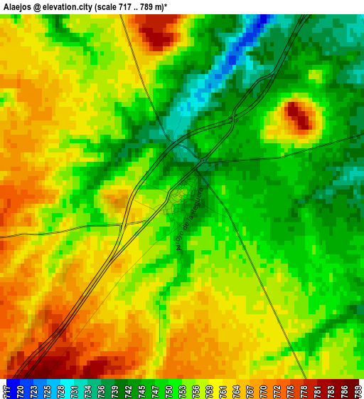
| \ | Map #1 | Topo.Map |
| Scale [m] | 717..789 m | × |
| Scale [ft] | 2352..2589 ft | × |
| Average | 754.8 m = 2476 ft | × |
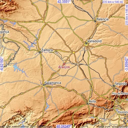
| Width | 7.34 km = 4.6 mi | 234.9 km = 146 mi |
| Height | 7.34 km = 4.6 mi | 234.9 km = 146 mi |
| ↑Max Latitude | 41.340322° | 42.3551° |
| Latitude at center | 41.30732° | 41.30732° |
| ↓Min Latitude | 41.274301° | 40.24243° |
| ← Min Longitude | -5.259615° | -6.62192° |
| Longitude center | -5.21567° | -5.21567° |
| →Max Longitude | -5.171725° | -3.80942° |
Nearby cities:
Cities around Alaejos sort by population:
• Nava del Rey elevation 751 m
11.5 km,  77°
77°
• Fresno El Viejo 759 m
13.6 km,  153°
153°
• Castronuño 705 m
10 km,  336°
336°
• Fuentelapeña 744 m
15.3 km,  246°
246°
• Siete Iglesias de Trabancos 721 m
5.6 km,  27°
27°
• Tarazona de Guareña 771 m
15.3 km,  190°
190°
• Villafranca de Duero 657 m
15.7 km,  332°
332°
• Nueva Villa de las Torres 745 m
14 km,  108°
108°
• Vadillo de la Guareña 716 m
11.8 km,  256°
256°
• Torrecilla de la Orden 779 m
9.9 km,  183°
183°
• Carpio 771 m
13.7 km,  139°
139°
• Castrillo de la Guareña 730 m
12.5 km,  227°
227°
Multilingual:
 En español:
Alaejos elevación 755 m.
 En France:
Alaejos élévation 755 m.


Sources and notes:
- [note 1] Map square and city borders are not equal. Map elevation data is calculated only from area inside that square.
- [src 1] Elevation data from geonames database provided with same terms of usage.
- [src 2] The elevation map of Alaejos is generated using elevation data from NASA's 3 arcsec (90m) resolution SRTM data.
- [src 3] Base (background) map © OpenStreetMap contributors tiles are generated by Geofabrik and OpenTopoMap.
Copyright & License:
This Alaejos Elevation Map is licensed under CC BY-SA. You may reuse any part from this page, if you give a proper credit by linking to this URL:
 More info on terms of use page.