Castronuño elevation
Castronuño (Castille and León, Provincia de Valladolid), Spain elevation is 705 meters and Castronuño elevation in feet is 2313 ft above sea level [src 1]. Castronuño is a seat of a third-order administrative division (feature code) with elevation that is 102 meters (335 ft) bigger than average city elevation in Spain.
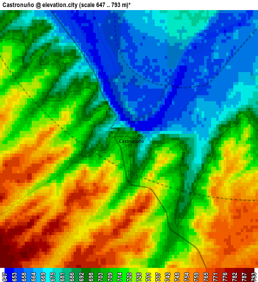
Below is the Elevation map of Castronuño, which displays elevation range with different colors. Scale of the first map is from 647 to 793 m (2123 to 2602 ft) with average elevation of 708.4 meters (=2324 ft) [note 1]
These maps also provides idea of topography and contour of this city, they are displayed at different zoom levels. More info about maps, scale and edge coordinates you can find below images.
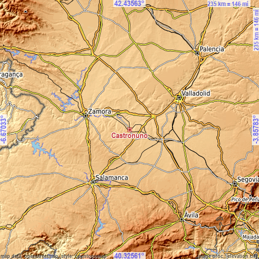
| \ | Map #1 | Topo.Map |
| Scale [m] | 647..793 m | × |
| Scale [ft] | 2123..2602 ft | × |
| Average | 708.4 m = 2324 ft | × |
| Width | 7.33 km = 4.6 mi | 234.6 km = 145.8 mi |
| Height | 7.33 km = 4.6 mi | 234.6 km = 145.8 mi |
| ↑Max Latitude | 41.422141° | 42.43563° |
| Latitude at center | 41.38918° | 41.38918° |
| ↓Min Latitude | 41.356202° | 40.32561° |
| ← Min Longitude | -5.308025° | -6.67033° |
| Longitude center | -5.26408° | -5.26408° |
| →Max Longitude | -5.220135° | -3.85783° |
Nearby cities:
Cities around Castronuño sort by population:
• Nava del Rey elevation 751 m
16.6 km,  113°
113°
• Alaejos 755 m
10 km,  156°
156°
• Morales de Toro 703 m
16.9 km,  347°
347°
• Fuentelapeña 744 m
18.3 km,  213°
213°
• Villabuena del Puente 703 m
12 km,  265°
265°
• Pollos 676 m
13.1 km,  62°
62°
• Siete Iglesias de Trabancos 721 m
7.8 km,  121°
121°
• San Román de Hornija 669 m
10.4 km, 350°
• Villafranca de Duero 657 m
5.8 km,  327°
327°
• Vadillo de la Guareña 716 m
14 km, 212°
• Torrecilla de la Abadesa 676 m
18.2 km,  54°
54°
• Valdefinjas 722 m
17.2 km,  293°
293°
Multilingual:
 En español:
Castronuño elevación 705 m.
 En France:
Castronuño élévation 705 m.
 Auf Deutsch:
Castronuño höhe über dem Meeresspiegel ist 705 m.

Sources and notes:
- [note 1] Map square and city borders are not equal. Map elevation data is calculated only from area inside that square.
- [src 1] Elevation data from geonames database provided with same terms of usage.
- [src 2] The elevation map of Castronuño is generated using elevation data from NASA's 3 arcsec (90m) resolution SRTM data.
- [src 3] Base (background) map © OpenStreetMap contributors tiles are generated by Geofabrik and OpenTopoMap.
Copyright & License:
This Castronuño Elevation Map is licensed under CC BY-SA. You may reuse any part from this page, if you give a proper credit by linking to this URL:
 More info on terms of use page.