Albillos elevation
Albillos (Castille and León, Provincia de Burgos), Spain elevation is 831 meters and Albillos elevation in feet is 2726 ft above sea level [src 1]. Albillos is a seat of a third-order administrative division (feature code) with elevation that is 228 meters (748 ft) bigger than average city elevation in Spain.
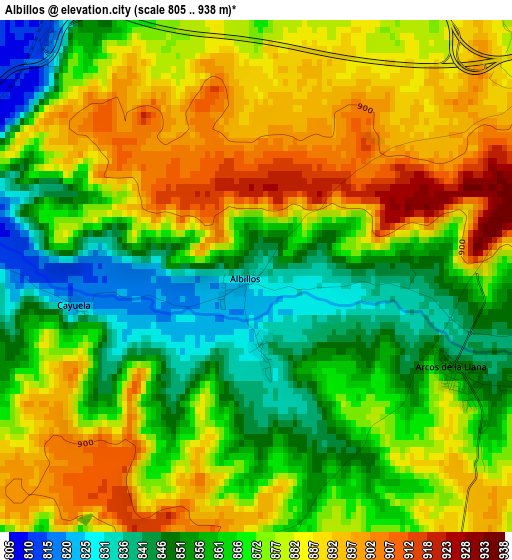
Below is the Elevation map of Albillos, which displays elevation range with different colors. Scale of the first map is from 805 to 938 m (2641 to 3077 ft) with average elevation of 871.9 meters (=2861 ft) [note 1]
These maps also provides idea of topography and contour of this city, they are displayed at different zoom levels. More info about maps, scale and edge coordinates you can find below images.
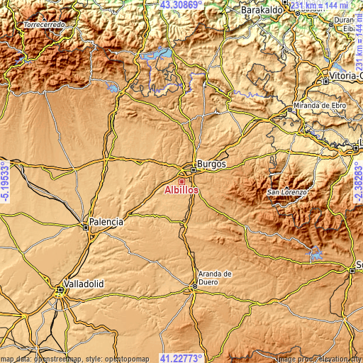
| \ | Map #1 | Topo.Map |
| Scale [m] | 805..938 m | × |
| Scale [ft] | 2641..3077 ft | × |
| Average | 871.9 m = 2861 ft | × |
| Width | 7.23 km = 4.5 mi | 231.4 km = 143.8 mi |
| Height | 7.23 km = 4.5 mi | 231.4 km = 143.8 mi |
| ↑Max Latitude | 42.309307° | 43.30869° |
| Latitude at center | 42.2768° | 42.2768° |
| ↓Min Latitude | 42.244276° | 41.22773° |
| ← Min Longitude | -3.833025° | -5.19533° |
| Longitude center | -3.78908° | -3.78908° |
| →Max Longitude | -3.745135° | -2.38283° |
Nearby cities:
Cities around Albillos sort by population:
• Villagonzalo-Pedernales elevation 901 m
5.2 km,  58°
58°
• Villalbilla de Burgos 834 m
7.9 km,  4°
4°
• Tardajos 827 m
8.4 km,  344°
344°
• Villariezo 860 m
4.7 km,  99°
99°
• Sarracín 861 m
8.7 km, 103°
• San Mamés de Burgos 843 m
6.7 km,  356°
356°
• Buniel 823 m
4.8 km,  325°
325°
• Rabé de las Calzadas 830 m
8 km, 332°
• Saldaña de Burgos 866 m
7.8 km,  105°
105°
• Cayuela 823 m
2.5 km,  258°
258°
• Frandovínez 824 m
5.5 km,  312°
312°
• Arcos 838 m
3.1 km, 111°
Multilingual:
 En español:
Albillos elevación 831 m.
 En France:
Albillos élévation 831 m.
 Auf Deutsch:
Albillos höhe über dem Meeresspiegel ist 831 m.

Sources and notes:
- [note 1] Map square and city borders are not equal. Map elevation data is calculated only from area inside that square.
- [src 1] Elevation data from geonames database provided with same terms of usage.
- [src 2] The elevation map of Albillos is generated using elevation data from NASA's 3 arcsec (90m) resolution SRTM data.
- [src 3] Base (background) map © OpenStreetMap contributors tiles are generated by Geofabrik and OpenTopoMap.
Copyright & License:
This Albillos Elevation Map is licensed under CC BY-SA. You may reuse any part from this page, if you give a proper credit by linking to this URL:
 More info on terms of use page.