Villariezo elevation
Villariezo (Castille and León, Provincia de Burgos), Spain elevation is 860 meters and Villariezo elevation in feet is 2822 ft above sea level [src 1]. Villariezo is a seat of a third-order administrative division (feature code) with elevation that is 257 meters (843 ft) bigger than average city elevation in Spain.
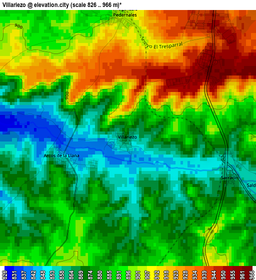
Below is the Elevation map of Villariezo, which displays elevation range with different colors. Scale of the first map is from 826 to 966 m (2710 to 3169 ft) with average elevation of 888.9 meters (=2916 ft) [note 1]
These maps also provides idea of topography and contour of this city, they are displayed at different zoom levels. More info about maps, scale and edge coordinates you can find below images.
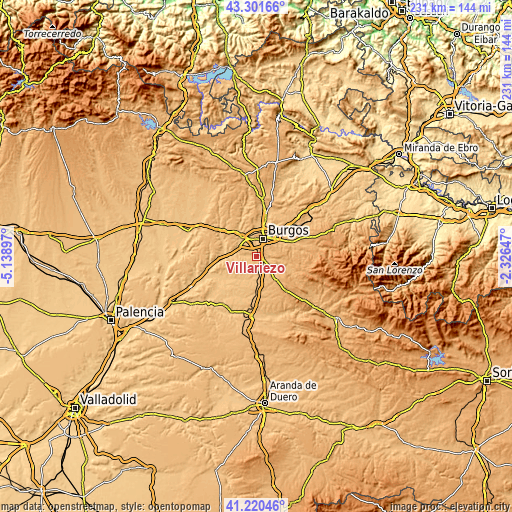
| \ | Map #1 | Topo.Map |
| Scale [m] | 826..966 m | × |
| Scale [ft] | 2710..3169 ft | × |
| Average | 888.9 m = 2916 ft | × |
| Width | 7.23 km = 4.5 mi | 231.4 km = 143.8 mi |
| Height | 7.23 km = 4.5 mi | 231.4 km = 143.8 mi |
| ↑Max Latitude | 42.302161° | 43.30166° |
| Latitude at center | 42.26965° | 42.26965° |
| ↓Min Latitude | 42.237123° | 41.22046° |
| ← Min Longitude | -3.776665° | -5.13897° |
| Longitude center | -3.73272° | -3.73272° |
| →Max Longitude | -3.688775° | -2.32647° |
Nearby cities:
Cities around Villariezo sort by population:
• Burgos elevation 863 m
8.3 km,  17°
17°
• Villagonzalo-Pedernales 901 m
3.5 km,  356°
356°
• Cardeñadijo 911 m
6.4 km,  55°
55°
• Cogollos 885 m
8.2 km,  160°
160°
• Modúbar de la Emparedada 885 m
6.1 km,  98°
98°
• Sarracín 861 m
4 km,  108°
108°
• Buniel 823 m
8.7 km,  302°
302°
• Albillos 831 m
4.7 km,  279°
279°
• Revillarruz 883 m
7.9 km,  123°
123°
• Saldaña de Burgos 866 m
3.2 km, 113°
• Cayuela 823 m
7.1 km,  272°
272°
• Arcos 838 m
1.8 km,  259°
259°
Multilingual:
 En español:
Villariezo elevación 860 m.
 En France:
Villariezo élévation 860 m.
 Auf Deutsch:
Villariezo höhe über dem Meeresspiegel ist 860 m.

Sources and notes:
- [note 1] Map square and city borders are not equal. Map elevation data is calculated only from area inside that square.
- [src 1] Elevation data from geonames database provided with same terms of usage.
- [src 2] The elevation map of Villariezo is generated using elevation data from NASA's 3 arcsec (90m) resolution SRTM data.
- [src 3] Base (background) map © OpenStreetMap contributors tiles are generated by Geofabrik and OpenTopoMap.
Copyright & License:
This Villariezo Elevation Map is licensed under CC BY-SA. You may reuse any part from this page, if you give a proper credit by linking to this URL:
 More info on terms of use page.