Aldealpozo elevation
Aldealpozo (Castille and León, Provincia de Soria), Spain elevation is 1049 meters and Aldealpozo elevation in feet is 3442 ft above sea level [src 1]. Aldealpozo is a seat of a third-order administrative division (feature code) with elevation that is 446 meters (1463 ft) bigger than average city elevation in Spain.
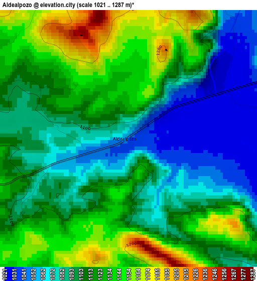
Below is the Elevation map of Aldealpozo, which displays elevation range with different colors. Scale of the first map is from 1021 to 1287 m (3350 to 4222 ft) with average elevation of 1108.3 meters (=3636 ft) [note 1]
These maps also provides idea of topography and contour of this city, they are displayed at different zoom levels. More info about maps, scale and edge coordinates you can find below images.
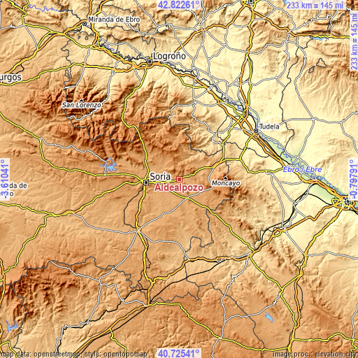
| \ | Map #1 | Topo.Map |
| Scale [m] | 1021..1287 m | × |
| Scale [ft] | 3350..4222 ft | × |
| Average | 1108.3 m = 3636 ft | × |
| Width | 7.29 km = 4.5 mi | 233.2 km = 144.9 mi |
| Height | 7.29 km = 4.5 mi | 233.2 km = 144.9 mi |
| ↑Max Latitude | 41.815341° | 42.82261° |
| Latitude at center | 41.78258° | 41.78258° |
| ↓Min Latitude | 41.749803° | 40.72541° |
| ← Min Longitude | -2.248105° | -3.61041° |
| Longitude center | -2.20416° | -2.20416° |
| →Max Longitude | -2.160215° | -0.79791° |
Nearby cities:
Cities around Aldealpozo sort by population:
• Almenar de Soria elevation 1020 m
11.2 km,  178°
178°
• Candilichera 1004 m
11.9 km,  222°
222°
• Almajano 1053 m
13.5 km,  304°
304°
• Arancón 1066 m
6.7 km,  286°
286°
• Pozalmuro 1051 m
8.5 km,  96°
96°
• Cabrejas del Campo 992 m
12.5 km,  205°
205°
• Narros 1114 m
10.5 km,  314°
314°
• Hinojosa del Campo 1036 m
10 km,  119°
119°
• Tajahuerce 1057 m
6.5 km,  136°
136°
• Villar del Campo 1036 m
4.6 km,  81°
81°
• Suellacabras 1200 m
8 km,  348°
348°
• Pinilla del Campo 1047 m
12.4 km,  126°
126°
Multilingual:
 En español:
Aldealpozo elevación 1049 m.
 En France:
Aldealpozo élévation 1049 m.
 Auf Deutsch:
Aldealpozo höhe über dem Meeresspiegel ist 1049 m.

Sources and notes:
- [note 1] Map square and city borders are not equal. Map elevation data is calculated only from area inside that square.
- [src 1] Elevation data from geonames database provided with same terms of usage.
- [src 2] The elevation map of Aldealpozo is generated using elevation data from NASA's 3 arcsec (90m) resolution SRTM data.
- [src 3] Base (background) map © OpenStreetMap contributors tiles are generated by Geofabrik and OpenTopoMap.
Copyright & License:
This Aldealpozo Elevation Map is licensed under CC BY-SA. You may reuse any part from this page, if you give a proper credit by linking to this URL:
 More info on terms of use page.