Aldeanueva del Camino elevation
Aldeanueva del Camino (Extremadura, Provincia de Cáceres), Spain elevation is 521 meters and Aldeanueva del Camino elevation in feet is 1709 ft above sea level [src 1]. Aldeanueva del Camino is a seat of a third-order administrative division (feature code) with elevation that is 82 meters (269 ft) smaller than average city elevation in Spain.
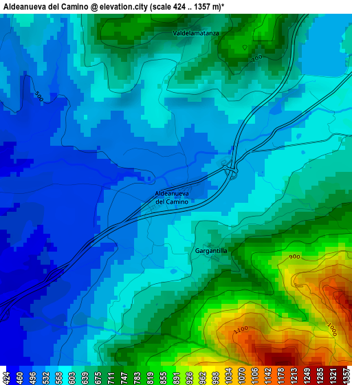
Below is the Elevation map of Aldeanueva del Camino, which displays elevation range with different colors. Scale of the first map is from 424 to 1357 m (1391 to 4452 ft) with average elevation of 633.1 meters (=2077 ft) [note 1]
These maps also provides idea of topography and contour of this city, they are displayed at different zoom levels. More info about maps, scale and edge coordinates you can find below images.
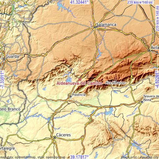
| \ | Map #1 | Topo.Map |
| Scale [m] | 424..1357 m | × |
| Scale [ft] | 1391..4452 ft | × |
| Average | 633.1 m = 2077 ft | × |
| Width | 7.46 km = 4.6 mi | 238.6 km = 148.3 mi |
| Height | 7.46 km = 4.6 mi | 238.6 km = 148.3 mi |
| ↑Max Latitude | 40.293327° | 41.32441° |
| Latitude at center | 40.2598° | 40.2598° |
| ↓Min Latitude | 40.226256° | 39.17817° |
| ← Min Longitude | -5.972805° | -7.33511° |
| Longitude center | -5.92886° | -5.92886° |
| →Max Longitude | -5.884915° | -4.52261° |
Nearby cities:
Cities around Aldeanueva del Camino sort by population:
• Hervás elevation 664 m
5.4 km,  76°
76°
• Navaconcejo 462 m
12.4 km,  137°
137°
• Zarza de Granadilla 394 m
10.5 km,  256°
256°
• Casas del Monte 584 m
6.9 km,  203°
203°
• Baños de Montemayor 696 m
8.6 km,  42°
42°
• Lagunilla 925 m
8.1 km,  333°
333°
• Gargantilla 638 m
1.5 km,  151°
151°
• Montemayor del Río 659 m
10.3 km,  16°
16°
• Abadía 453 m
4.2 km,  269°
269°
• Segura de Toro 639 m
4.3 km, 202°
• Peñacaballera 875 m
10.9 km,  31°
31°
• Jarilla 492 m
11.6 km,  212°
212°
Multilingual:
 En español:
Aldeanueva del Camino elevación 521 m.
 En France:
Aldeanueva del Camino élévation 521 m.
 Auf Deutsch:
Aldeanueva del Camino höhe über dem Meeresspiegel ist 521 m.
 На русском:
Aldeanueva del Camino высота над уровнем моря 521 м
Sources and notes:
- [note 1] Map square and city borders are not equal. Map elevation data is calculated only from area inside that square.
- [src 1] Elevation data from geonames database provided with same terms of usage.
- [src 2] The elevation map of Aldeanueva del Camino is generated using elevation data from NASA's 3 arcsec (90m) resolution SRTM data.
- [src 3] Base (background) map © OpenStreetMap contributors tiles are generated by Geofabrik and OpenTopoMap.
Copyright & License:
This Aldeanueva del Camino Elevation Map is licensed under CC BY-SA. You may reuse any part from this page, if you give a proper credit by linking to this URL:
 More info on terms of use page.