Lagunilla elevation
Lagunilla (Castille and León, Provincia de Salamanca), Spain elevation is 925 meters and Lagunilla elevation in feet is 3035 ft above sea level [src 1]. Lagunilla is a seat of a third-order administrative division (feature code) with elevation that is 322 meters (1056 ft) bigger than average city elevation in Spain.
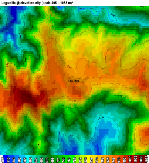
Below is the Elevation map of Lagunilla, which displays elevation range with different colors. Scale of the first map is from 495 to 1083 m (1624 to 3553 ft) with average elevation of 777.6 meters (=2551 ft) [note 1]
These maps also provides idea of topography and contour of this city, they are displayed at different zoom levels. More info about maps, scale and edge coordinates you can find below images.
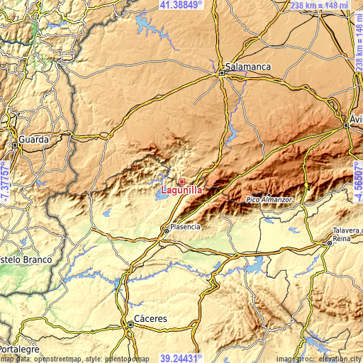
| \ | Map #1 | Topo.Map |
| Scale [m] | 495..1083 m | × |
| Scale [ft] | 1624..3553 ft | × |
| Average | 777.6 m = 2551 ft | × |
| Width | 7.45 km = 4.6 mi | 238.4 km = 148.1 mi |
| Height | 7.45 km = 4.6 mi | 238.4 km = 148.1 mi |
| ↑Max Latitude | 40.358405° | 41.38849° |
| Latitude at center | 40.32491° | 40.32491° |
| ↓Min Latitude | 40.291398° | 39.24431° |
| ← Min Longitude | -6.015265° | -7.37757° |
| Longitude center | -5.97132° | -5.97132° |
| →Max Longitude | -5.927375° | -4.56507° |
Nearby cities:
Cities around Lagunilla sort by population:
• Hervás elevation 664 m
10.7 km,  124°
124°
• Aldeanueva del Camino 521 m
8.1 km,  153°
153°
• Baños de Montemayor 696 m
9.5 km,  95°
95°
• Gargantilla 638 m
9.5 km, 153°
• Puerto de Béjar 952 m
11.7 km,  75°
75°
• Montemayor del Río 659 m
7 km,  68°
68°
• Abadía 453 m
7.3 km,  184°
184°
• Colmenar de Montemayor 838 m
8.4 km,  8°
8°
• Segura de Toro 639 m
11.4 km,  170°
170°
• Aldeacipreste 876 m
8.8 km,  45°
45°
• Peñacaballera 875 m
9.6 km, 77°
• Valdelageve 648 m
5.2 km,  341°
341°
Multilingual:
 En español:
Lagunilla elevación 925 m.
 En France:
Lagunilla élévation 925 m.
 Auf Deutsch:
Lagunilla höhe über dem Meeresspiegel ist 925 m.

Sources and notes:
- [note 1] Map square and city borders are not equal. Map elevation data is calculated only from area inside that square.
- [src 1] Elevation data from geonames database provided with same terms of usage.
- [src 2] The elevation map of Lagunilla is generated using elevation data from NASA's 3 arcsec (90m) resolution SRTM data.
- [src 3] Base (background) map © OpenStreetMap contributors tiles are generated by Geofabrik and OpenTopoMap.
Copyright & License:
This Lagunilla Elevation Map is licensed under CC BY-SA. You may reuse any part from this page, if you give a proper credit by linking to this URL:
 More info on terms of use page.