Alguaire elevation
Alguaire (Catalonia, Província de Lleida), Spain elevation is 310 meters and Alguaire elevation in feet is 1017 ft above sea level [src 1]. Alguaire is a populated place (feature code) with elevation that is 293 meters (961 ft) smaller than average city elevation in Spain.
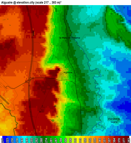
Below is the Elevation map of Alguaire, which displays elevation range with different colors. Scale of the first map is from 217 to 383 m (712 to 1257 ft) with average elevation of 302.1 meters (=991 ft) [note 1]
These maps also provides idea of topography and contour of this city, they are displayed at different zoom levels. More info about maps, scale and edge coordinates you can find below images.

| \ | Map #1 | Topo.Map |
| Scale [m] | 217..383 m | × |
| Scale [ft] | 712..1257 ft | × |
| Average | 302.1 m = 991 ft | × |
| Width | 7.29 km = 4.5 mi | 233.4 km = 145 mi |
| Height | 7.29 km = 4.5 mi | 233.3 km = 145 mi |
| ↑Max Latitude | 41.769814° | 42.7778° |
| Latitude at center | 41.73703° | 41.73703° |
| ↓Min Latitude | 41.704229° | 40.67912° |
| ← Min Longitude | 0.540555° | -0.82175° |
| Longitude center | 0.5845° | 0.5845° |
| →Max Longitude | 0.628445° | 1.99075° |
Nearby cities:
Cities around Alguaire sort by population:
• Lleida elevation 185 m
13.7 km,  166°
166°
• Almacelles 253 m
12.2 km,  267°
267°
• Alpicat 260 m
8.3 km,  196°
196°
• Almenar 307 m
6.7 km,  348°
348°
• Alfarràs 264 m
8.9 km,  359°
359°
• Torrefarrera 218 m
7.3 km, 165°
• Alcoletge 217 m
13.5 km,  137°
137°
• Albesa 243 m
6.5 km,  74°
74°
• Térmens 211 m
15.3 km,  98°
98°
• Corbins 176 m
11.3 km,  121°
121°
• Algerri 348 m
9.7 km,  26°
26°
• Castelló de Farfanya 337 m
15.2 km,  54°
54°
Multilingual:
 En español:
Alguaire elevación 310 m.
 En France:
Alguaire élévation 310 m.
 Auf Deutsch:
Alguaire höhe über dem Meeresspiegel ist 310 m.

Sources and notes:
- [note 1] Map square and city borders are not equal. Map elevation data is calculated only from area inside that square.
- [src 1] Elevation data from geonames database provided with same terms of usage.
- [src 2] The elevation map of Alguaire is generated using elevation data from NASA's 3 arcsec (90m) resolution SRTM data.
- [src 3] Base (background) map © OpenStreetMap contributors tiles are generated by Geofabrik and OpenTopoMap.
Copyright & License:
This Alguaire Elevation Map is licensed under CC BY-SA. You may reuse any part from this page, if you give a proper credit by linking to this URL:
 More info on terms of use page.