Alloza elevation
Alloza (Aragon, Provincia de Teruel), Spain elevation is 661 meters and Alloza elevation in feet is 2169 ft above sea level [src 1]. Alloza is a seat of a third-order administrative division (feature code) with elevation that is 58 meters (190 ft) bigger than average city elevation in Spain.
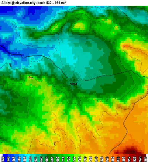
Below is the Elevation map of Alloza, which displays elevation range with different colors. Scale of the first map is from 532 to 961 m (1745 to 3153 ft) with average elevation of 706.7 meters (=2319 ft) [note 1]
These maps also provides idea of topography and contour of this city, they are displayed at different zoom levels. More info about maps, scale and edge coordinates you can find below images.
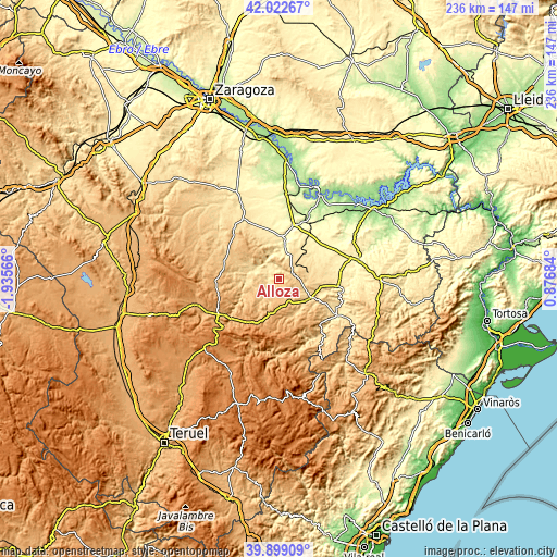
| \ | Map #1 | Topo.Map |
| Scale [m] | 532..961 m | × |
| Scale [ft] | 1745..3153 ft | × |
| Average | 706.7 m = 2319 ft | × |
| Width | 7.38 km = 4.6 mi | 236.1 km = 146.7 mi |
| Height | 7.38 km = 4.6 mi | 236.1 km = 146.7 mi |
| ↑Max Latitude | 41.002593° | 42.02267° |
| Latitude at center | 40.96942° | 40.96942° |
| ↓Min Latitude | 40.93623° | 39.89909° |
| ← Min Longitude | -0.573355° | -1.93566° |
| Longitude center | -0.52941° | -0.52941° |
| →Max Longitude | -0.485465° | 0.87684° |
Nearby cities:
Cities around Alloza sort by population:
• Andorra elevation 712 m
6.9 km,  83°
83°
• Alcorisa 631 m
15.1 km,  124°
124°
• Albalate del Arzobispo 355 m
17 km,  5°
5°
• Ariño 521 m
8.6 km,  322°
322°
• Oliete 557 m
12.6 km,  284°
284°
• Alacón 636 m
15.5 km,  293°
293°
• Molinos 836 m
17.8 km,  158°
158°
• Estercuel 837 m
15.4 km,  214°
214°
• Berge 727 m
15.1 km,  145°
145°
• Crivillén 782 m
10.4 km,  202°
202°
• Gargallo 945 m
15.6 km, 197°
• Alcaine 664 m
14.9 km,  263°
263°
Multilingual:
 En español:
Alloza elevación 661 m.
 En France:
Alloza élévation 661 m.


Sources and notes:
- [note 1] Map square and city borders are not equal. Map elevation data is calculated only from area inside that square.
- [src 1] Elevation data from geonames database provided with same terms of usage.
- [src 2] The elevation map of Alloza is generated using elevation data from NASA's 3 arcsec (90m) resolution SRTM data.
- [src 3] Base (background) map © OpenStreetMap contributors tiles are generated by Geofabrik and OpenTopoMap.
Copyright & License:
This Alloza Elevation Map is licensed under CC BY-SA. You may reuse any part from this page, if you give a proper credit by linking to this URL:
 More info on terms of use page.