Crivillén elevation
Crivillén (Aragon, Provincia de Teruel), Spain elevation is 782 meters and Crivillén elevation in feet is 2566 ft above sea level [src 1]. Crivillén is a seat of a third-order administrative division (feature code) with elevation that is 179 meters (587 ft) bigger than average city elevation in Spain.
Below is the Elevation map of Crivillén, which displays elevation range with different colors. Scale of the first map is from 654 to 1077 m (2146 to 3533 ft) with average elevation of 856.4 meters (=2810 ft) [note 1]
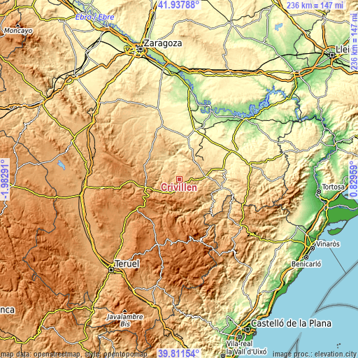
These maps also provides idea of topography and contour of this city, they are displayed at different zoom levels. More info about maps, scale and edge coordinates you can find below images.
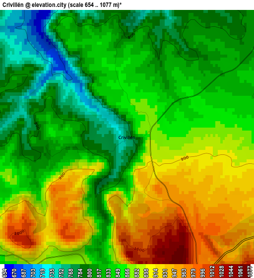
| \ | Map #1 | Topo.Map |
| Scale [m] | 654..1077 m | × |
| Scale [ft] | 2146..3533 ft | × |
| Average | 856.4 m = 2810 ft | × |
| Width | 7.39 km = 4.6 mi | 236.4 km = 146.9 mi |
| Height | 7.39 km = 4.6 mi | 236.4 km = 146.9 mi |
| ↑Max Latitude | 40.916466° | 41.93788° |
| Latitude at center | 40.88325° | 40.88325° |
| ↓Min Latitude | 40.850017° | 39.81154° |
| ← Min Longitude | -0.620605° | -1.98291° |
| Longitude center | -0.57666° | -0.57666° |
| →Max Longitude | -0.532715° | 0.82959° |
Nearby cities:
Cities around Crivillén sort by population:
• Andorra elevation 712 m
15 km,  46°
46°
• Alloza 661 m
10.4 km,  22°
22°
• Molinos 836 m
12.7 km,  123°
123°
• Estercuel 837 m
5.6 km,  236°
236°
• Berge 727 m
12.9 km,  102°
102°
• Ejulve 1121 m
12 km,  170°
170°
• Castel de Cabra 1086 m
13.5 km,  228°
228°
• Cañizar del Olivar 961 m
9.4 km,  217°
217°
• Gargallo 945 m
5.3 km,  187°
187°
• Obón 701 m
12.5 km,  280°
280°
• Alcaine 664 m
13.4 km,  305°
305°
• Torre de las Arcas 943 m
12.7 km,  248°
248°
Multilingual:
 En español:
Crivillén elevación 782 m.
 En France:
Crivillén élévation 782 m.
 Auf Deutsch:
Crivillén höhe über dem Meeresspiegel ist 782 m.

Sources and notes:
- [note 1] Map square and city borders are not equal. Map elevation data is calculated only from area inside that square.
- [src 1] Elevation data from geonames database provided with same terms of usage.
- [src 2] The elevation map of Crivillén is generated using elevation data from NASA's 3 arcsec (90m) resolution SRTM data.
- [src 3] Base (background) map © OpenStreetMap contributors tiles are generated by Geofabrik and OpenTopoMap.
Copyright & License:
This Crivillén Elevation Map is licensed under CC BY-SA. You may reuse any part from this page, if you give a proper credit by linking to this URL:
 More info on terms of use page.