Allueva elevation
Allueva (Aragon, Provincia de Teruel), Spain elevation is 1197 meters and Allueva elevation in feet is 3927 ft above sea level [src 1]. Allueva is a seat of a third-order administrative division (feature code) with elevation that is 594 meters (1949 ft) bigger than average city elevation in Spain.
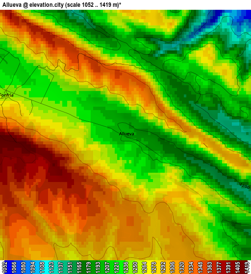
Below is the Elevation map of Allueva, which displays elevation range with different colors. Scale of the first map is from 1052 to 1419 m (3451 to 4656 ft) with average elevation of 1262.5 meters (=4142 ft) [note 1]
These maps also provides idea of topography and contour of this city, they are displayed at different zoom levels. More info about maps, scale and edge coordinates you can find below images.
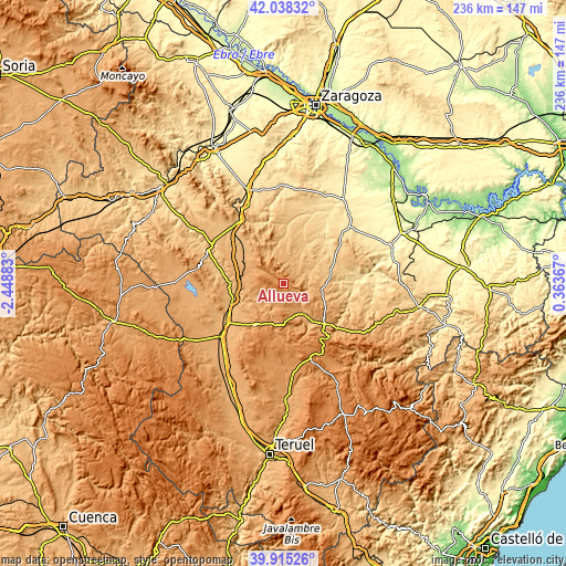
| \ | Map #1 | Topo.Map |
| Scale [m] | 1052..1419 m | × |
| Scale [ft] | 3451..4656 ft | × |
| Average | 1262.5 m = 4142 ft | × |
| Width | 7.38 km = 4.6 mi | 236.1 km = 146.7 mi |
| Height | 7.38 km = 4.6 mi | 236.1 km = 146.7 mi |
| ↑Max Latitude | 41.018495° | 42.03832° |
| Latitude at center | 40.98533° | 40.98533° |
| ↓Min Latitude | 40.952148° | 39.91526° |
| ← Min Longitude | -1.086525° | -2.44883° |
| Longitude center | -1.04258° | -1.04258° |
| →Max Longitude | -0.998635° | 0.36367° |
Nearby cities:
Cities around Allueva sort by population:
• Loscos elevation 982 m
10.6 km,  359°
359°
• Torrecilla del Rebollar 1145 m
8.8 km,  196°
196°
• Barrachina 1049 m
12.7 km,  219°
219°
• Huesa del Común 858 m
10.8 km,  74°
74°
• Monforte de Moyuela 1004 m
8.1 km,  17°
17°
• Villanueva del Rebollar de la Sierra 1084 m
10.9 km,  164°
164°
• Maicas 971 m
12.9 km,  99°
99°
• Bea 1127 m
10.5 km,  302°
302°
• Segura de los Baños 1126 m
9.1 km,  122°
122°
• Fonfría 1249 m
3.7 km,  287°
287°
• Anadón 1114 m
5 km,  93°
93°
• Salcedillo 1194 m
4.1 km,  128°
128°
Multilingual:
 En español:
Allueva elevación 1197 m.
 En France:
Allueva élévation 1197 m.
 Auf Deutsch:
Allueva höhe über dem Meeresspiegel ist 1197 m.

Sources and notes:
- [note 1] Map square and city borders are not equal. Map elevation data is calculated only from area inside that square.
- [src 1] Elevation data from geonames database provided with same terms of usage.
- [src 2] The elevation map of Allueva is generated using elevation data from NASA's 3 arcsec (90m) resolution SRTM data.
- [src 3] Base (background) map © OpenStreetMap contributors tiles are generated by Geofabrik and OpenTopoMap.
Copyright & License:
This Allueva Elevation Map is licensed under CC BY-SA. You may reuse any part from this page, if you give a proper credit by linking to this URL:
 More info on terms of use page.