Almaluez elevation
Almaluez (Castille and León, Provincia de Soria), Spain elevation is 822 meters and Almaluez elevation in feet is 2697 ft above sea level [src 1]. Almaluez is a seat of a third-order administrative division (feature code) with elevation that is 219 meters (719 ft) bigger than average city elevation in Spain.
Below is the Elevation map of Almaluez, which displays elevation range with different colors. Scale of the first map is from 796 to 973 m (2612 to 3192 ft) with average elevation of 865.6 meters (=2840 ft) [note 1]
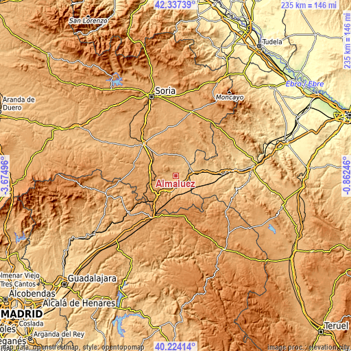
These maps also provides idea of topography and contour of this city, they are displayed at different zoom levels. More info about maps, scale and edge coordinates you can find below images.
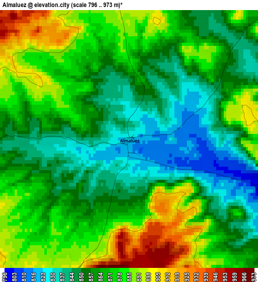
| \ | Map #1 | Topo.Map |
| Scale [m] | 796..973 m | × |
| Scale [ft] | 2612..3192 ft | × |
| Average | 865.6 m = 2840 ft | × |
| Width | 7.34 km = 4.6 mi | 235 km = 146 mi |
| Height | 7.34 km = 4.6 mi | 235 km = 146 mi |
| ↑Max Latitude | 41.322332° | 42.33739° |
| Latitude at center | 41.28932° | 41.28932° |
| ↓Min Latitude | 41.256292° | 40.22414° |
| ← Min Longitude | -2.312655° | -3.67496° |
| Longitude center | -2.26871° | -2.26871° |
| →Max Longitude | -2.224765° | -0.86246° |
Nearby cities:
Cities around Almaluez sort by population:
• Arcos de Jalón elevation 823 m
8.2 km,  183°
183°
• Ariza 721 m
18.2 km,  81°
81°
• Santa María de Huerta 814 m
8.9 km,  106°
106°
• Monteagudo de las Vicarías 793 m
11.8 km,  44°
44°
• Monreal de Ariza 755 m
13.7 km,  88°
88°
• Morón de Almazán 996 m
18.3 km,  318°
318°
• Alconchel de Ariza 897 m
15.5 km,  127°
127°
• Torrehermosa 836 m
13.1 km,  116°
116°
• Taroda 1030 m
15.2 km,  295°
295°
• Alentisque 1064 m
15.5 km,  340°
340°
• Cañamaque 966 m
17.4 km,  8°
8°
• Pozuel de Ariza 793 m
12 km,  55°
55°
Multilingual:
 En español:
Almaluez elevación 822 m.
 En France:
Almaluez élévation 822 m.
 Auf Deutsch:
Almaluez höhe über dem Meeresspiegel ist 822 m.

Sources and notes:
- [note 1] Map square and city borders are not equal. Map elevation data is calculated only from area inside that square.
- [src 1] Elevation data from geonames database provided with same terms of usage.
- [src 2] The elevation map of Almaluez is generated using elevation data from NASA's 3 arcsec (90m) resolution SRTM data.
- [src 3] Base (background) map © OpenStreetMap contributors tiles are generated by Geofabrik and OpenTopoMap.
Copyright & License:
This Almaluez Elevation Map is licensed under CC BY-SA. You may reuse any part from this page, if you give a proper credit by linking to this URL:
 More info on terms of use page.