Cañamaque elevation
Cañamaque (Castille and León, Provincia de Soria), Spain elevation is 966 meters and Cañamaque elevation in feet is 3169 ft above sea level [src 1]. Cañamaque is a seat of a third-order administrative division (feature code) with elevation that is 363 meters (1191 ft) bigger than average city elevation in Spain.
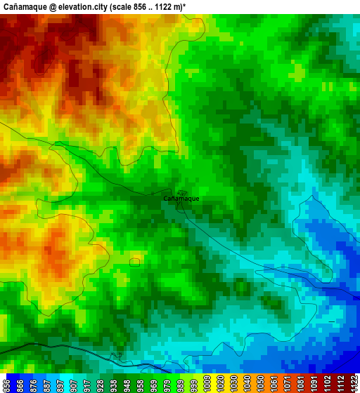
Below is the Elevation map of Cañamaque, which displays elevation range with different colors. Scale of the first map is from 856 to 1122 m (2808 to 3681 ft) with average elevation of 969.2 meters (=3180 ft) [note 1]
These maps also provides idea of topography and contour of this city, they are displayed at different zoom levels. More info about maps, scale and edge coordinates you can find below images.
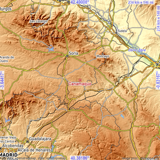
| \ | Map #1 | Topo.Map |
| Scale [m] | 856..1122 m | × |
| Scale [ft] | 2808..3681 ft | × |
| Average | 969.2 m = 3180 ft | × |
| Width | 7.33 km = 4.6 mi | 234.4 km = 145.6 mi |
| Height | 7.33 km = 4.6 mi | 234.4 km = 145.6 mi |
| ↑Max Latitude | 41.477463° | 42.49008° |
| Latitude at center | 41.44453° | 41.44453° |
| ↓Min Latitude | 41.41158° | 40.38186° |
| ← Min Longitude | -2.281865° | -3.64417° |
| Longitude center | -2.23792° | -2.23792° |
| →Max Longitude | -2.193975° | -0.83167° |
Nearby cities:
Cities around Cañamaque sort by population:
• Monteagudo de las Vicarías elevation 793 m
10.5 km,  147°
147°
• Torlengua 869 m
6.4 km,  79°
79°
• Bordalba 915 m
14.6 km,  102°
102°
• Nolay 1077 m
13.1 km,  314°
314°
• Alentisque 1064 m
8.3 km,  251°
251°
• Bliecos 1040 m
9.7 km,  343°
343°
• Velilla de los Ajos 1010 m
5.3 km, 343°
• Soliedra 1102 m
12.3 km,  282°
282°
• Escobosa de Almazán 1086 m
12.1 km,  292°
292°
• Momblona 1064 m
9.1 km,  269°
269°
• Pozuel de Ariza 793 m
12.8 km, 145°
• Maján 1146 m
6 km,  296°
296°
Multilingual:
 En español:
Cañamaque elevación 966 m.
 En France:
Cañamaque élévation 966 m.
 Auf Deutsch:
Cañamaque höhe über dem Meeresspiegel ist 966 m.

Sources and notes:
- [note 1] Map square and city borders are not equal. Map elevation data is calculated only from area inside that square.
- [src 1] Elevation data from geonames database provided with same terms of usage.
- [src 2] The elevation map of Cañamaque is generated using elevation data from NASA's 3 arcsec (90m) resolution SRTM data.
- [src 3] Base (background) map © OpenStreetMap contributors tiles are generated by Geofabrik and OpenTopoMap.
Copyright & License:
This Cañamaque Elevation Map is licensed under CC BY-SA. You may reuse any part from this page, if you give a proper credit by linking to this URL:
 More info on terms of use page.