Alpanseque elevation
Alpanseque (Castille and León, Provincia de Soria), Spain elevation is 1114 meters and Alpanseque elevation in feet is 3655 ft above sea level [src 1]. Alpanseque is a seat of a third-order administrative division (feature code) with elevation that is 511 meters (1677 ft) bigger than average city elevation in Spain.
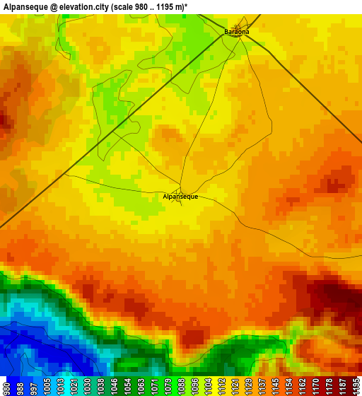
Below is the Elevation map of Alpanseque, which displays elevation range with different colors. Scale of the first map is from 980 to 1195 m (3215 to 3921 ft) with average elevation of 1116 meters (=3661 ft) [note 1]
These maps also provides idea of topography and contour of this city, they are displayed at different zoom levels. More info about maps, scale and edge coordinates you can find below images.
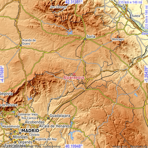
| \ | Map #1 | Topo.Map |
| Scale [m] | 980..1195 m | × |
| Scale [ft] | 3215..3921 ft | × |
| Average | 1116 m = 3661 ft | × |
| Width | 7.35 km = 4.6 mi | 235.1 km = 146.1 mi |
| Height | 7.35 km = 4.6 mi | 235.1 km = 146.1 mi |
| ↑Max Latitude | 41.298074° | 42.31351° |
| Latitude at center | 41.26505° | 41.26505° |
| ↓Min Latitude | 41.232009° | 40.19948° |
| ← Min Longitude | -2.714585° | -4.07689° |
| Longitude center | -2.67064° | -2.67064° |
| →Max Longitude | -2.626695° | -1.26439° |
Nearby cities:
Cities around Alpanseque sort by population:
• Caltojar elevation 968 m
17.1 km,  332°
332°
• Villasayas 1028 m
11 km,  27°
27°
• Valdelcubo 1020 m
4.3 km,  185°
185°
• Alcubilla de las Peñas 1132 m
12.1 km,  97°
97°
• Sienes 1039 m
7.3 km,  168°
168°
• Yelo 1130 m
14 km,  112°
112°
• Paredes de Sigüenza 1005 m
5.8 km,  244°
244°
• Barcones 1099 m
12.5 km,  283°
283°
• Cincovillas 1020 m
14 km, 241°
• Rello 1076 m
10 km,  318°
318°
• Alcolea de las Peñas 1012 m
11.4 km, 237°
• Tordelrábano 1020 m
9 km,  234°
234°
Multilingual:
 En español:
Alpanseque elevación 1114 m.
 En France:
Alpanseque élévation 1114 m.
 Auf Deutsch:
Alpanseque höhe über dem Meeresspiegel ist 1114 m.

Sources and notes:
- [note 1] Map square and city borders are not equal. Map elevation data is calculated only from area inside that square.
- [src 1] Elevation data from geonames database provided with same terms of usage.
- [src 2] The elevation map of Alpanseque is generated using elevation data from NASA's 3 arcsec (90m) resolution SRTM data.
- [src 3] Base (background) map © OpenStreetMap contributors tiles are generated by Geofabrik and OpenTopoMap.
Copyright & License:
This Alpanseque Elevation Map is licensed under CC BY-SA. You may reuse any part from this page, if you give a proper credit by linking to this URL:
 More info on terms of use page.