Caltojar elevation
Caltojar (Castille and León, Provincia de Soria), Spain elevation is 968 meters and Caltojar elevation in feet is 3176 ft above sea level [src 1]. Caltojar is a seat of a third-order administrative division (feature code) with elevation that is 365 meters (1198 ft) bigger than average city elevation in Spain.
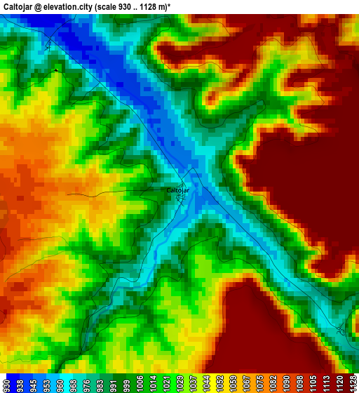
Below is the Elevation map of Caltojar, which displays elevation range with different colors. Scale of the first map is from 930 to 1128 m (3051 to 3701 ft) with average elevation of 1039.2 meters (=3409 ft) [note 1]
These maps also provides idea of topography and contour of this city, they are displayed at different zoom levels. More info about maps, scale and edge coordinates you can find below images.
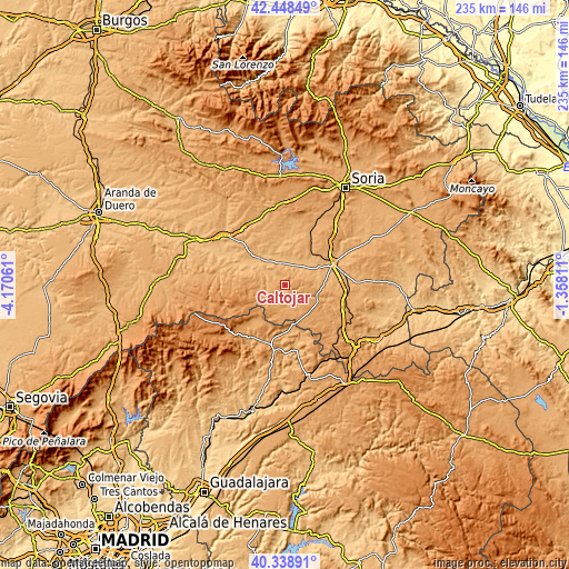
| \ | Map #1 | Topo.Map |
| Scale [m] | 930..1128 m | × |
| Scale [ft] | 3051..3701 ft | × |
| Average | 1039.2 m = 3409 ft | × |
| Width | 7.33 km = 4.6 mi | 234.6 km = 145.8 mi |
| Height | 7.33 km = 4.6 mi | 234.6 km = 145.8 mi |
| ↑Max Latitude | 41.435214° | 42.44849° |
| Latitude at center | 41.40226° | 41.40226° |
| ↓Min Latitude | 41.369289° | 40.33891° |
| ← Min Longitude | -2.808305° | -4.17061° |
| Longitude center | -2.76436° | -2.76436° |
| →Max Longitude | -2.720415° | -1.35811° |
Nearby cities:
Cities around Caltojar sort by population:
• Berlanga de Duero elevation 937 m
10.7 km,  311°
311°
• Matamala de Almazán 950 m
15.4 km,  41°
41°
• Bayubas de Abajo 927 m
17.7 km,  321°
321°
• Velamazán 980 m
7.5 km,  46°
46°
• Barca 967 m
13.2 km,  63°
63°
• Tajueco 933 m
16.5 km,  334°
334°
• Alpanseque 1114 m
17.1 km,  152°
152°
• Villasayas 1028 m
14 km,  113°
113°
• Barcones 1099 m
13.1 km,  199°
199°
• Rello 1076 m
7.8 km,  170°
170°
• Arenillas 1096 m
9.2 km,  228°
228°
• Centenera de Andaluz 945 m
12.2 km,  18°
18°
Multilingual:
 En español:
Caltojar elevación 968 m.
 En France:
Caltojar élévation 968 m.
 Auf Deutsch:
Caltojar höhe über dem Meeresspiegel ist 968 m.

Sources and notes:
- [note 1] Map square and city borders are not equal. Map elevation data is calculated only from area inside that square.
- [src 1] Elevation data from geonames database provided with same terms of usage.
- [src 2] The elevation map of Caltojar is generated using elevation data from NASA's 3 arcsec (90m) resolution SRTM data.
- [src 3] Base (background) map © OpenStreetMap contributors tiles are generated by Geofabrik and OpenTopoMap.
Copyright & License:
This Caltojar Elevation Map is licensed under CC BY-SA. You may reuse any part from this page, if you give a proper credit by linking to this URL:
 More info on terms of use page.