Altzaga elevation
Altzaga (Basque Country, Gipuzkoa), Spain elevation is 298 meters and Altzaga elevation in feet is 978 ft above sea level [src 1]. Altzaga is a seat of a third-order administrative division (feature code) with elevation that is 305 meters (1001 ft) smaller than average city elevation in Spain.
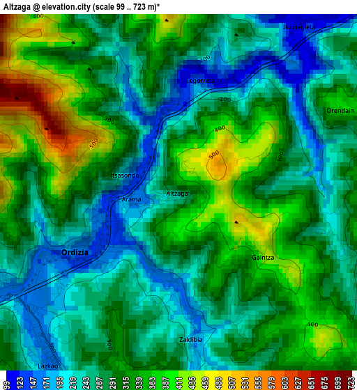
Below is the Elevation map of Altzaga, which displays elevation range with different colors. Scale of the first map is from 99 to 723 m (325 to 2372 ft) with average elevation of 295.4 meters (=969 ft) [note 1]
These maps also provides idea of topography and contour of this city, they are displayed at different zoom levels. More info about maps, scale and edge coordinates you can find below images.
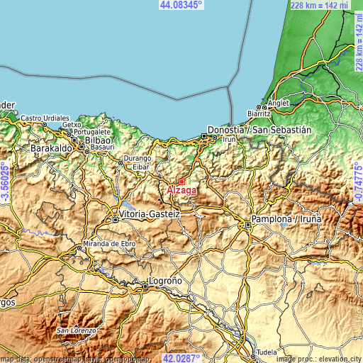
| \ | Map #1 | Topo.Map |
| Scale [m] | 99..723 m | × |
| Scale [ft] | 325..2372 ft | × |
| Average | 295.4 m = 969 ft | × |
| Width | 7.14 km = 4.4 mi | 228.5 km = 142 mi |
| Height | 7.14 km = 4.4 mi | 228.5 km = 142 mi |
| ↑Max Latitude | 43.096777° | 44.08345° |
| Latitude at center | 43.06468° | 43.06468° |
| ↓Min Latitude | 43.032566° | 42.0287° |
| ← Min Longitude | -2.197945° | -3.56025° |
| Longitude center | -2.154° | -2.154° |
| →Max Longitude | -2.110055° | -0.74775° |
Nearby cities:
Cities around Altzaga sort by population:
• Beasain elevation 236 m
4.1 km,  247°
247°
• Legorreta 129 m
2.2 km,  7°
7°
• Orendain 376 m
3.8 km,  65°
65°
• Arama 166 m
0.9 km,  260°
260°
• Baliarrain 290 m
2.2 km,  76°
76°
• Lazkao 170 m
4.4 km,  216°
216°
• Abaltzisketa 369 m
4.4 km,  115°
115°
• Ikaztegieta 131 m
4.1 km,  36°
36°
• Zaldibia 172 m
3.1 km,  174°
174°
• Ordizia 145 m
2.2 km,  237°
237°
• Gaintza 438 m
2.2 km,  127°
127°
• Itsasondo 153 m
1 km,  299°
299°
Multilingual:
 En español:
Alzaga elevación 298 m.
 En France:
Altzaga élévation 298 m.


Sources and notes:
- [note 1] Map square and city borders are not equal. Map elevation data is calculated only from area inside that square.
- [src 1] Elevation data from geonames database provided with same terms of usage.
- [src 2] The elevation map of Altzaga is generated using elevation data from NASA's 3 arcsec (90m) resolution SRTM data.
- [src 3] Base (background) map © OpenStreetMap contributors tiles are generated by Geofabrik and OpenTopoMap.
Copyright & License:
This Altzaga Elevation Map is licensed under CC BY-SA. You may reuse any part from this page, if you give a proper credit by linking to this URL:
 More info on terms of use page.